No Early Summer for Mid-Atlantic Region
06/11/2023, 12:29 pm EDTFocus On U.S. Corn Belt Drought
06/18/2023, 5:48 pm EDT
Fig. 1: Satellite view of the North Atlantic basin.
Today’s discussion: The shear axis across the tropical/subtropical North Atlantic basin is strongest over the Gulf of Mexico and somewhat broken in the central and eastern basin (Fig. 1). There are no tropical cyclone risks today. Last night’s week 2-4 outlook emphasized a wetter than normal regime stretched across the tropical North Atlantic due to wet trade winds south of the Bermuda High (located a few hundred miles east of Bermuda). Today’s 10-day percent of normal rainfall forecast by ECMWF conveys a similar pattern and increases the risk of a tropical system in the southwest Caribbean Sea and central tropics (Fig. 2). The developing and steady wet trade wind regime in the tropics is inspired in-part by what is likely to be the warmest SSTA pattern on record (Fig. 3) for the main development region (MDR) for North Atlantic hurricanes as defined by the tropical North Atlantic (TNA) index. The previous warmest TNA index for June was +1.1 in 2010.
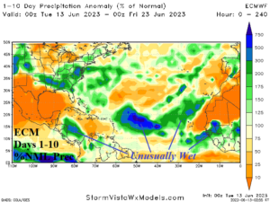
Fig. 2: ECMWF 10-day percent of normal rainfall forecast across the North Atlantic basin.
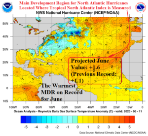
Fig. 3: The main development region for North Atlantic hurricanes located between the Caribbean Sea and northwest coast of Africa is the warmest on record (compared to normal) for the month of June.