Updated North Atlantic Basin 2023 Tropical Cyclone Outlook Revised More Dangerous
06/01/2023, 5:30 pm EDTNo Early Summer for Mid-Atlantic Region
06/11/2023, 12:29 pm EDT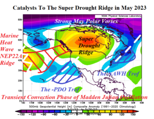
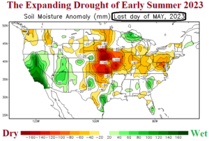
Discussion: A combination of climate factors caused an upper-level high-pressure ridge in Canada to amplify attendant drying character from West Canada to the Great Plains during May.
First, upper troughs aligned across the cool waters related to the cool phase of the Pacific decadal oscillation (-PDO) off the California/Baja California Coast and just off the U.S. East Coast associated with the North Atlantic warm hole (NAWH) created an opportunity for a compensating upper-level high-pressure ridge to form in-between in Canada.
Second, the Canadian upper-level ridge was made stronger compensating for an unusually intense polar vortex near the North Pole well-identified by the strong May 2023 positive phase arctic oscillation (+AO).
Third, although El Nino has not yet officially formed, the May 2023 southern oscillation index (SOI) was a very El Nino-like -1.5 and inspired by the convection phase of the Madden Julian oscillation (MJO) rolling across the equatorial Pacific during late meteorological spring. The -SOI pattern created an El Nino-like climate forcing lower pressure in the subtropics while northern latitudes compensated with high pressure helping the Canadian upper ridge to expand into the U.S.
Week-2 Ahead Forecast valid June 12-19, 2023: Cooler pattern with some patchy Midwest showers while Texas shifts hotter.
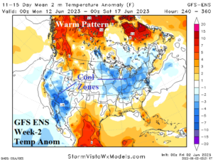
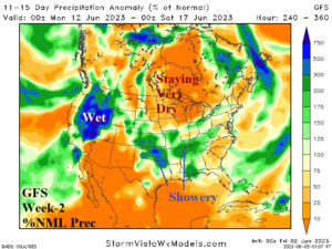
Discussion: First and foremost, the intense May 2023 polar vortex fades (fast) in June and the upper ridge in central North America shifts north into the polar region as a high-latitude block forms and both arctic oscillation (AO) and North Atlantic oscillation (NAO) flip to the negative phase. To compensate, the upper trough associated with the NAWH pattern east of New England expands across the East U.S. through mid-June. The result? A cooler U.S. pattern for mid-June with the anomalous warmth shifting northward in Canada. The upper trough will trigger hit-and-miss beneficial rains for the central Great Plains and eastward to the Tennessee Valley. The Upper Midwest will remain dry.
Week-3 Ahead Forecast valid June 19-26, 2023: Red flag! Models expanding warmth into East is wrong!
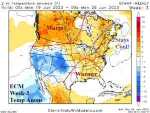
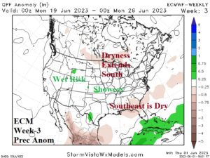
Discussion: Taking a look at the day-15 upper air of both the GFS and ECM Ensembles and you’ll find the NAWH trough remains and could regain strength. So…all “weeklies” models warming the East is wrong. The Northeast stays cool while the Gulf States may shift hotter. A narrow band of showers across the southern Corn Belt during the period while the West stays cool and wet-biased.
Week-4 Ahead Forecast valid June 26-July 3, 2023: Canadian warmth and dryness amplifies back into the Northern U.S.
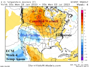
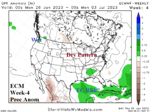
Discussion: Canadian warmth expands. However, only some of that warmth extends to the Northern U.S. while the East is likely near normal. The Midwest is likely drier than normal while wet weather risk is centered on Washington and the Gulf of Mexico.