Short-term High Impact Weather Forecasts Includes Continued Cold in Europe and Brazil Wet-to-Dry Flip
01/07/2024, 10:59 am ESTShock Cold Next Week and Following Week Based on Today’s 12Z GFS
01/11/2024, 12:43 pm ESTCharts of the day: Southern U.S. chill risk increases.
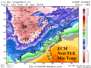
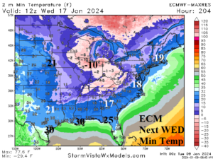
Discussion: ECM roars the arctic air into the Gulf region next TUE and WED morning. The trend is colder and additional chill is possible due to proximity of snow cover preventing the arctic air from moderating upon approach to the Gulf of Mexico. Note the well below zero values into Arkansas Tuesday morning. A frigid punch to the Chicago area is indicated.
Medium-range 6-10 Day Forecast Valid January 14-18, 2024 (24-hour change right)

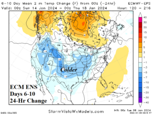
Discussion: Unfortunately, the already frigid forecast is trending colder with a stronger southern reach. Snow cover is farther south and enables <0F risk to reach Oklahoma and Arkansas. The cold air mass is making a stronger impact on the East.
Medium-range 11-15 Day Forecast Valid January 19-23, 2024 (24-hour change right)
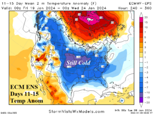
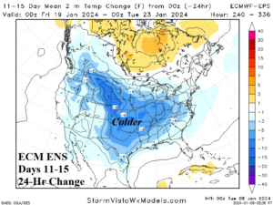
Discussion: The macroscale climate (tropical Pacific Madden Julian oscillation episode) favors a warmer U.S. pattern. However, expansive snow cover across the U.S. delays the warming. Forecast models trend colder in the 11-15-day period as the harsh cold does not moderate (yet).
U.S. Medium-range Precipitation Forecast
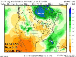
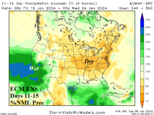
Discussion: The immense storm track of this week eases next week and regenerates in California during the 11-15-day period.
Days 16-20 Extended range Temperature Forecast valid January 24-28, 2024 (previous below)

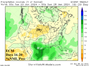
Discussion: The extended-range forecast indicates significant warming and heavy rain in Texas. The dramatic turnaround is supported by the macroscale climate but snow cover could delay a significant warm-up.