December 2023 Second Least Snowy (December) of 1966-2023
01/05/2024, 9:06 am ESTArctic Impact on Southern U.S. Increasing
01/09/2024, 6:56 am EST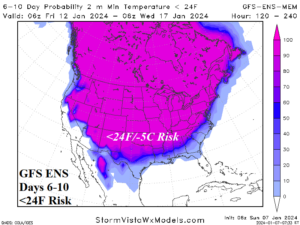
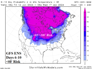
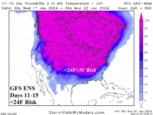
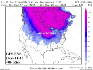
Fig. 1-4: GFS ENS 6-10-day and 11-15-day forecasts of <24F/-5C and <0F/-18C risk across the U.S.
Discussion: Forecast models are agreeable on the infiltration of cold arctic air into the U.S. during the medium range. The 6-10-day forecast indicates cold 24F/-5C reaches southward into central Texas, the Interior Southeast, and close to the Atlantic Seaboard (Fig. 1) while <0F/-18C reaches the central Great Plains and Midwest States (Fig. 2). The 11-15-day projection of <24F/-5C is stronger into the East (Fig. 3) while the 11-15-day risk of <0F/-18C budges into New England (Fig. 4). A significant catalyst to the expanding cold is an emerging U.S. snow cover forecast to cover about 65% of the U.S. by Jan. 21 (Fig. 5). In the Southeast and East U.S. significant flooding from heavy rainstorms is expected into mid-month (Fig. 6).
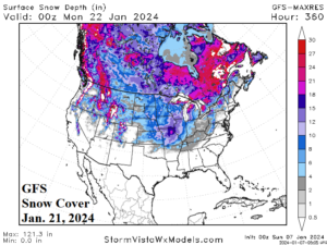

Fig. 5-6: The GFS 15-day snow cover projection across the U.S. by the GFS and the ECM ENS 15-day precipitation amount forecast.
Europe/Western Russia is locked-into a cold pattern featuring arctic air in Northwest Eurasia expanding into Europe with increasing intensity (Fig. 7) as snow cover shifts farther south over the next 15 days (Fig. 8).

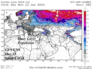
Fig. 7-8: The Europe/Western Russia 15-day temperature anomaly forecast and snow cover expansion.
The South America early summer rainfall pattern has changed. Wet weather has increased across the Brazil drought zone in early January while previously wet climate in Southeast Brazil to Northeast Argentina has flipped drier in recent days (Fig. 9). The latest mega-cluster ensemble forecast indicates wet weather continues in Central/East Brazil this week (Fig. 10) followed by a drier climate returning to Brazil in the medium range while wet weather in Argentina returns (Fig. 11-12).
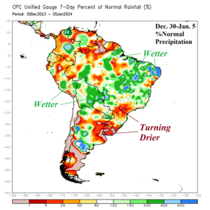


Fig. 9-12: The latest weekly percent of normal rainfall observations for South America and the 15-day medium-range percent of normal rainfall forecast.