Dry Concerns Increase Great Plains/Eastern Europe; Indian Wet Monsoon to Reactivate
08/25/2023, 9:29 am EDTExtreme Rains Across China
08/28/2023, 4:10 am EDTHighlight: TD 10 becomes a tropical storm today, should reach major hurricane status in northeast Gulf. Medium-range forecasts continue to trend hotter. Central/East-central U.S. drying out fast!

Fig. 1: North Atlantic basin satellite view of TD 10 and Franklin.
Discussion: At 8AM EDT, T.D. 10 is nearing tropical storm strength located about 70 miles southeast of Cozumel, MX. TD 10 drifted slightly southward overnight. However, a northerly track is forecast to develop tonight/Monday as an upper ridge east of this system strengthens. The upper shear pattern across the northern Gulf remains although slightly weaker than yesterday. NOAA/NHC intensifies TD 10 to a tropical storm today and a hurricane Tuesday with a north-northeast trek into northwest Florida Wednesday morning. Tropical cyclone models are in reasonable agreement on the track of this system and spike intensity to category-1 hurricane levels at landfall into northwest Florida. Climate Impact Company WARNS users that the NOAA/NHC forecast (and tropical cyclone model) intensity forecast is likely too weak. The record warm eastern Gulf of Mexico should easily allow this system to gain major hurricane intensity in the northeast Gulf. Preferred is a consensus between the HWRF and HMON hurricane forecast models which indicate a 950-953 category-3 major hurricane making landfall in northwest Florida somewhere between Franklin and Taylor Counties around 2-5AM WED. This system tracks well inland with ferocity before moving off the North Carolina Coast Thursday night. A major windstorm with extreme rain and a destructive storm surge into Western Florida north of Tampa to Franklin County should be planned now.
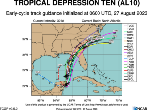
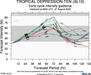
Fig. 2-3: Tropical cyclone models forecast tracks and intensity for TD 10. WARNING: Intensity forecast is much too low.
Meanwhile, Hurricane Franklin is getting ready to become the first major hurricane of the year well southwest of Bermuda. Franklin will move northwest, north, and northeastward staying to the west and northwest of Bermuda early-to-midweek. Franklin stays out to sea although impact on tides and coastal flooding is likely to emerge on the East Coast.
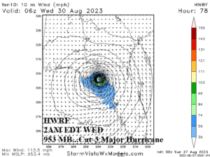
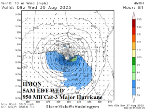
Fig. 4-5: A likely best guess landfall SLP forecast by HWRF and HMON hurricane forecast models indicates a 950-953 category 3 major hurricane.
Currently, extreme heat remains an issue in the west/north Gulf of Mexico States. The most dangerous heat continues in the Houston to New Orleans stretch. Additionally, excessive heat has emerged across the Southwest U.S. Desert and heat advisories stretch to the Southern California Coast. A Heat Advisory is also posted for western Washington.
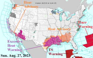
Fig. 6: Current NOAA/NWS weather watch, warning, and advisory areas.
Medium-range forecasts were hotter yesterday and that trend continues today. The heat is not quite as strong as last week, nevertheless extremely hot for September. Examples of the type of heat to expect is near 100F from Des Moines to Kansas City to Little Rock. Hottest peaks occur in the Sep. 4-7 timeframe. The 15-day percent of normal rainfall forecast also emphasizes the dryness in the Central/East-central U.S. The Midwest drought is “not as bad as early summer but worsening rapidly” while Texas/Louisiana drought is historic, worsening, and expanding.
The U.S. population weight CDD forecast through mid-September indicates much above normal demand to produce electricity and the trend since Friday is sharply warmer.
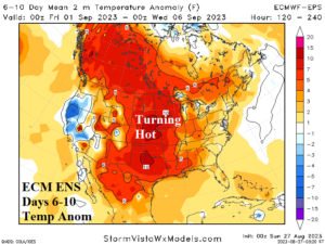
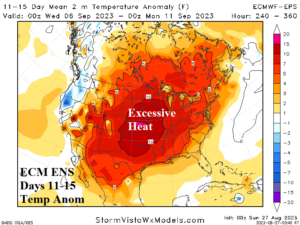
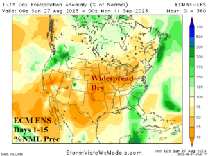
Fig. 7-9: ECM ENS medium-range temperature anomaly forecast and the 15-day percent of normal rainfall outlook.
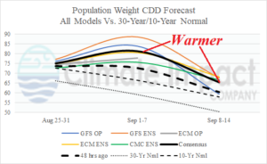
Fig. 10: U.S. population weight CDD forecast utilizing all models, their consensus, and comparison with 48 hours ago and the 10-year/30-year normal.