TD 10 Becomes Tropical Storm Today, Likely Major Hurricane NE Gulf Later Tuesday
08/27/2023, 8:50 am EDTIdalia Will Strike Northwest FLA Coast as Strong Cat-4 Major Hurricane
08/30/2023, 6:02 am EDT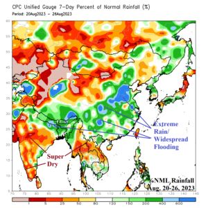
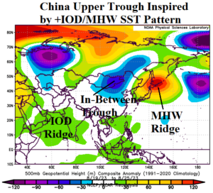
Fig. 1-2: The Asia 7-day percent of normal rainfall for Aug. 20-26, 2023 and upper air pattern for that same timeframe.
Discussion: During the past week extreme rains have caused massive evacuations in China due to flash flooding and swollen rivers. Much of the China wheat, soybean, and corn areas have been hit hard by heavy rain (Fig. 1). The upper-level low pressure trough during the past week has lodged itself over Northeast China located in-between an amplified upper ridge over Northern Japan in response to a large marine heat wave in that vicinity and an upper ridge which has defeated the Indian Monsoon (Fig. 2). The upper ridge into India is north of increasing convection over the warmer than normal western tropical Indian Ocean characteristic of a developing positive phase of the Indian Ocean dipole (+IOD). This week, the crop areas dry-out. However, the next problem for China is an approaching major typhoon. Category-4 Major Typhoon Saola will turn northwest and into Southern Taiwan in 3-4 days and strike the Southeast China Coast Friday (Fig. 3). Meanwhile, an emerging MJO presence in the Indian Ocean should reverse the dry pattern across India to wetter weather in the 8-14-day period (Fig. 4). The MJO influence on Australian rainfall is limited although isolated heavy rain is indicated by ECM on the East/Southeast and Southwest Coast (Fig. 5).
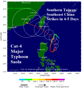
Fig. 3: The 5-day forecast track for Category-4 Major Typhoon Saola.
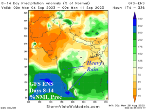
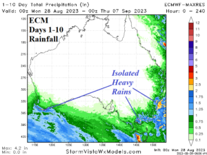
Fig. 4-5: GFS ENS 8-14-day percent of normal rainfall across India and 1-10-day ECM projection of rainfall for Australia.