Extreme Rains Across China
08/28/2023, 4:10 am EDTLate Season Heatwave Focused on the Mid-Atlantic Next Week
08/31/2023, 8:25 am EDT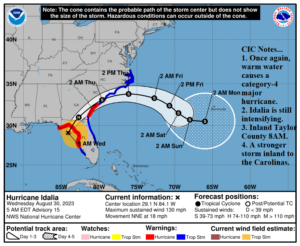
Fig. 1: Latest NOAA/NHC 5-day track for Major Hurricane Idalia.
Today’s discussion: At 5AM EDT, NOAA/NHC indicates Category-4 Major Hurricane Idalia was located at 29.1N/84.1W or about 90 miles south of Tallahassee, FL. Maximum sustained wind is now 130 mph. Idalia is moving north-northeast at 18 mph. Central pressure has lowered to 940 MB. The overnight trend is a stronger and faster major hurricane. Several hours of additional intensification are expected before landfall along coastal Taylor County around 8AM (Fig. 1).
The stronger storm, faster speed, and shift northeastward to quickly reach the South Carolina Coast indicates weakening of Idalia will occur more slowly. Consequently, a Hurricane Warning extends to the central and northern Georgia and southern South Carolina Coast. Idalia exits the Carolina Coast with greater ferocity and Tropical Storm Warnings are extended northward to the VA/NC state line.
Hurricane force wind extends to 20 miles either side of the forecast track which takes sustained hurricane force wind as far north as southern Georgia this afternoon (Fig. 2). Tropical storm force wind will affect all of west, northwest, and north Florida and well into Georgia adding the Coastal Carolinas (Fig. 3).
NOAA/NHC increased the storm surge forecast to 12-16 feet from Wakulla/Jefferson County line to Yankeetown (Fig. 4). The storm surge forecast along the Coastal Carolinas has also increased to 3-5 feet in some areas. The rainfall profile indicates heaviest rain shifts to along the forecast track and northward as Idalia accelerates northeast and east once inland to the South Carolina Coast (Fig. 5). Tornado risk extends across much of northern Florida to southern Georgia and the eastern Carolinas the next 24 hours. A Tornado Watch is posted for west and north Florida.
Once Idalia departs the South Carolina Coast early tomorrow morning, the storm drifts eastward and slows down in the wake of slower steering currents caused by building high pressure in the wake of departing Major Hurricane Franklin. Idalia is forecast to drift toward Bermuda with uncertainty on redevelopment over the weekend.
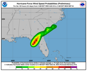
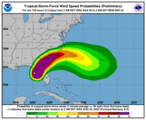
Fig. 2-3: NOAA/NHC hurricane and tropical storm force wind probability forecast. Hurricane force wind will extend to southern Georgia. Hurricane force gusts are possible on the south coast of South Carolina.
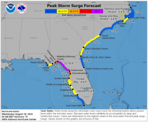
Fig. 4: NOAA/NHC storm surge forecast for Idalia. The forecast increases surge to 12-16 feet near and east of landfall. Storm surge increases to 3-5 feet along parts of the Carolina Coast.
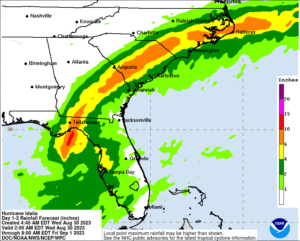
Fig. 5: NOAA/NHC rainfall projection associated with Idalia. Note that the heaviest rain shifts to along the forecast track and northward as Idalia accelerates northeastward. Tornado risk extends across west and north Florida to the coastal Carolinas.