Early Season Cold Does Not Necessarily Mean Cold Winter Ahead
10/31/2023, 9:11 am EDTDrought Developing in Australia Although Patchy Rains In 15-Day Outlook
11/02/2023, 5:55 am EDT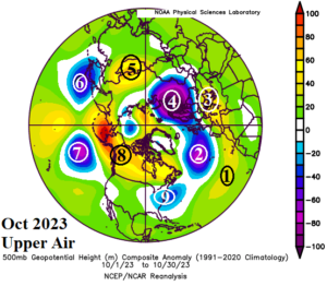
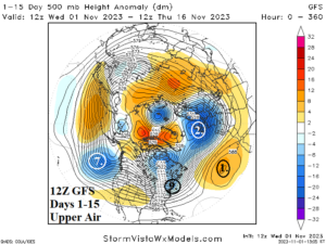
Fig. 1-2: The 12Z GFS 24-hour temperature change for the medium-range and 15-day 24-hour precipitation forecast change.
Discussion: What were the climate drivers in October (Fig. 1) just-ahead of today’s onset of the cold season? We begin off the Northwest Coast of Africa and southwest of Europe where a strong marine heatwave evolved during 2023 (No. 1). Consequently, across the warm water zone an amplified upper ridge formed and delivered another hot summer to Europe. Recently, the semi-permanent North Atlantic upper trough regenerated (No. 2) and is entraining some of the low-level atmosphere moisture induced by the warm SSTA in the southeastern North Atlantic to cause 2-3 weeks of rainstorms across Europe.
LEARNING POINT: Marine heat waves have profound influence on climate which can change depending on time of year.
East of the North Atlantic trough, the Southern Europe ridge stayed in-place in October (No. 3). However, to compensate for the Europe ridge, an upper trough formed over Northwest Russia inducing cold enough air to produce above normal snow cover (No. 4). These amplified upper-level systems provided further compensation downstream with an upper ridge over Mongolia (No. 5) and stormy trough off the Japan Coast (No. 6).
In October, a large trough formed north of Hawaii (No. 7) and was compensated for to the north and northeast by a persistent upper ridge from Alaska across Canada (No. 8). Finally, an upper trough forming late last spring on the U.S. East Coast weakening briefly during summer returned in mid-autumn (No. 9).
Where are these features shifting through the first half of November? The BIG players are the upper trough(s) over eastern North America and Europe (Fig. 2). Warm U.S. forecasts may be too warm as the upper trough lingers while Europe is stormy!
At midday, the 12Z GFS maintains a cool to temperate bias in the East while the warm pattern resides in the West based on the 15-day forecast (Fig. 3). In the tropics, potential for trouble looms. However, the risk to Florida as previously indicated has diminished. The 12Z GFS has two areas of late season concern over Central America and northeast of the Leeward Islands with no U.S. threat (Fig. 4). The U.S. gas population weight forecast continues to trend warmer next week and remains below normal heating demand Nov. 10-16 (Table 1).
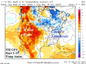
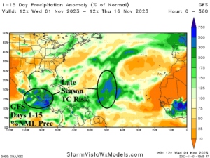
Fig. 3-4: The 12Z GFS 15-day U.S. temperature anomaly forecast and percent normal rainfall in the tropics over the next 15 days.
| Dates | HDD Forecast | 12-Hr Change | 24-Hr Change | 30-Year NML | 10-Year NML |
| Oct. 27-Nov. 2
| 110.3 | -0.1 | +0.1 | 93.8 | 87.8 |
| Nov. 3-9
| 85.6 | -0.5 | -10.8 | 109.6 | 107.9 |
| Nov. 10-16
| 114.0 | +0.1 | -1.7 | 125.5 | 126.8 |
Table 1: The 12Z GFS U.S. gas population weight HDD forecast compared to 12 and 24 hours ago.
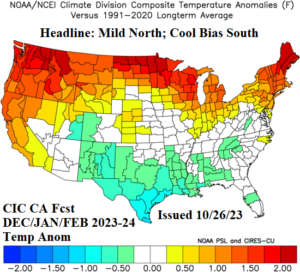
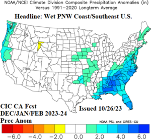
Fig. 5-6: The Climate Impact Company winter 2023-24 outlook.
The FINAL U.S. winter 2023-24 outlook was issued last week (Fig. 5-6). As a review, the 2023-24 winter climate is inspired by a moderate strength El Nino climate. Consequently, a Southern U.S. cool and stormy signature is indicated with anomalous warmth across the Northern States and Canada. The Pacific Northwest is also stormy at times. Cold can occur at times as just observed in the Central and East to close October. However, cold air masses are not likely to include widespread arctic air potential during upcoming winter. Cold air masses are brief and typically replaced rapidly by Pacific-born milder regimes. The Southern U.S. storm track will generate snow, most likely in mid-to-late winter, including the southern Plains to Tennessee Valley and Northeast Corridor.