Unusually Expansive Wet Mid-Troposphere (For El Nino) Across Tropical Pacific
10/30/2023, 3:26 pm EDTWhere Did The Northern Hemisphere Upper Air Pattern Originate?
11/01/2023, 4:50 pm EDT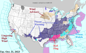
Fig. 1: NOAA/NWS weather watch, warning, and advisories.
Discussion: Record autumn cold is featured within a Freeze Warning zone extending from Texas across the Tennessee and Ohio Valley(s) and into the East U.S. (Fig. 1). Several days of <32F are likely in much of the eastern warning areas while the cold risk abates after tomorrow morning in the East-central U.S. Early season <32F is not terribly unusual. Early <32F in Dallas (tomorrow morning) was exceeded in 2019 (Oct. 31) from the past 10 years (Fig. 2). Note that early or late extremes in <32F observations were followed by a warm winter in Dallas. Elsewhere, high wind lingers in Coastal Southern California for one more day. There is some snow in the forecast for the Chicago area, northern Ohio Valley, and into northern New England to finish October. Important weather risks ahead include a potential “atmospheric river” episode into the Coastal Northwest U.S. most focused on Northern California (Fig. 3) while tropical trouble brewing in the Caribbean Sea late this week could affect Florida and the Bahamas next week while the Northeast also turns stormy (Fig. 4). The forecast confidence for the described storminess is below average as forecast models for next week are fluctuating. The latest gas population weight HDD forecast for the U.S. through mid-November indicates a cold Canadian Ensemble solution while European Ensemble is considerably warmer. The consensus of all forecast models is similar to 24 hours ago (Fig. 5).
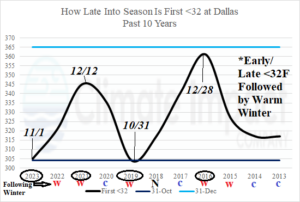
Fig. 2: First morning of <32F in Dallas, TX past 10 years is quite variable with early/late extremes typically followed by a warm winter.
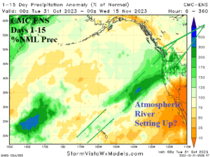
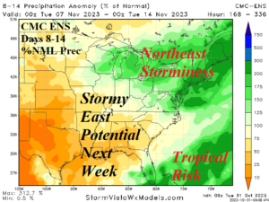
Fig. 3-4: A possible “atmospheric river” event into the West Coast ahead while next week is potentially stormy in the East U.S.
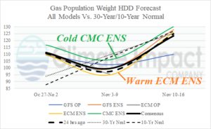
Fig. 5: U.S. population weight HDD forecast based on all models, their consensus, and comparing with 24 hours ago and the 30-year/10-year normal.