Subsurface Equatorial Pacific Warmth to Sustain El Nino Strengthening Near Dateline
10/24/2023, 8:24 am EDTEarly Season Cold Does Not Necessarily Mean Cold Winter Ahead
10/31/2023, 9:11 am EDT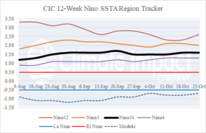
Fig. 1: The 12-week Nino SSTA regions indicate steady moderate-to-strong oceanic El Nino.
Discussion: The Nino SSTA regions remain remarkably consistent indicating a moderate to strong oceanic El Nino episode (Fig. 1). The Nino34 SSTA was steady at +1.6C last week. In the subsurface, upper ocean heat to maintain El Nino remains steady while broadening to west of the Dateline (Fig. 2). The southern oscillation index (SOI) is choppy weak negative/weak positive of late which continues to identify the atmospheric El Nino as weak. Another indicator of the weaker El Nino climate signature during October 2023 compared to the same month during the 3 strongest El Nino’s on record is the large area of wet (relative humidity) conditions of the current month compared to the RH signature of October in 1982, 1997, and 2015 which consolidates wet RH in the equatorial East Pacific (Fig. 3-4). Sharper relative humidity, vertical velocity, and sea surface temperature anomaly gradient across the tropical Pacific during ENSO events favors stronger reaction from the climate which is not the case in 2023.
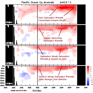
Fig. 2: The POAMA subsurface equatorial ocean heat anomalies for the past 4 months indicate steady fuel supply to maintain El Nino.
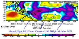
Fig. 3: The 500 MB relative humidity anomaly in the tropics for October 2023.
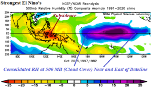
Fig. 4: The 500 MB relative humidity in the tropics for the month of October for the 3 strongest El Nino’s on record.