Tropical Storm Lee to Undergo “Explosive” Strengthening to a Potential Category-5 Major Hurricane
09/06/2023, 8:14 am EDTLee Still an Intensifying Powerful Category-5 Major Hurricane
09/08/2023, 8:53 am EDT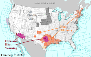
Fig. 1: Latest NOAA/NWS weather watch, warning, and advisory areas.
Discussion: Late calendar summer heatwaves continue in three regions including the Northeast U.S., Texas/Louisiana, and the Southwest Desert (Fig. 1). The Northeast heat wave begins to ease tomorrow as thunderstorm advances toward the coast. The Texas/Louisiana heat eases later this weekend as gully-washer thundershowers develop. The Southwest Desert heatwave is cut by thunderstorm activity early next week. Severe thunderstorms are in the forecast for northern Virginia to New York State today (Fig. 2) likely repeating tomorrow although closer to the coast (Fig. 3). Gully-washer rains for the Interior Northeast are likely to persist through the weekend. NOAA/WPC indicates 2-4 in. of rain from western Virginia to northern New England into early next week (Fig. 4). A second area of heavy rain is in the forecast for SUN/MON in Kansas stretching into Texas ending the ongoing heatwave. The U.S. population weight CDD forecast reveals above normal cooling demand on a national level continuing in the short-term easing back toward normal in the extended range (Fig. 5).
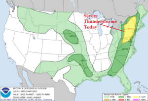
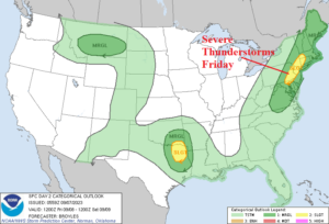
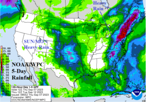
Fig. 2-4: NOAA/SPC severe weather outlook for today and Friday plus the 5-day NOAA/WPC rainfall forecast.
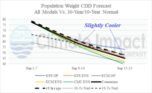
Fig. 5: U.S. population weight CDD projection utilizing all models, their consensus and comparison with 48 hours ago plus the 10-year/30-year normal.