Very Dry Month of August in Australia
09/04/2023, 9:25 am EDTMore Flooding Rains Interior Northeast U.S. Corridor
09/07/2023, 8:21 am EDTHighlight: Tropical Storm Lee to undergo “explosive” strengthening to a potential category-5 major hurricane by the weekend.
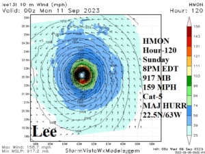
Fig. 1: HMON hurricane forecast model projects a category-5 major hurricane by 8PM EDT Sunday evening at 22.5N/63.0W.
Discussion: At 5AM EDT, Tropical Storm Lee was located at 13.7N/44.6W or about 1265 miles east-southeast of the Northern Leeward Islands. Lee is moving west-northwest at 14 mph with top wind 65 mph and surface pressure 997 MB. Lee is moving west-northwest on the south side of a subtropical high-pressure area (“Bermuda High”) forecast to remain in-place into the weekend. Consequently, the west-northwest movement should not change much through this weekend. The environment is ideal for intensification featuring light shear, excellent upper-level ventilation, and passage over somewhat warmer than normal water. NOAA/NHC has stated that “explosive” intensification of this system is likely late this week as Lee becomes a major hurricane. The HMON hurricane forecast model projects a 917 MB category-5 major hurricane well north of Puerto Rico Sunday evening (Fig. 1). After day-5 (Sunday) where Lee will travel is very uncertain and obviously a major U.S. East Coast concern considering the west-northwest movement at category-5 intensity late Sunday. However, for now, most tropical cyclone forecast models are turning Lee northward guided by the steering current on the back side of the Bermuda High and an approaching upper trough over the Northeast U.S. (Fig. 2). Forecast confidence in this sharp north turn is LOW and a farther westward path could easily occur as indicated by both ECM and GFS. The storm could also slow down once nearing 70W longitude. The official NOAA/NHC 5-day forecast track takes Lee west-northwestward the next 5 days with strengthening to a category-4 major hurricane just under category-5 qualifications by day-5 (Fig. 3).
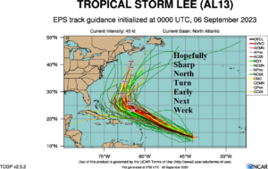
Fig. 2: Ensembles project a north turn by Lee after 5 days.
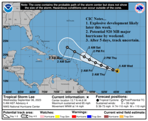
Fig. 3: The NOAA/NHC 5-day forecast track for Lee.