Dry Mid-Troposphere across The Gulf/Western Caribbean Suppress TC Risk
08/09/2023, 7:49 am EDTNorth Atlantic Basin Tropical Cyclone Season Scorecard
08/11/2023, 8:07 am EDT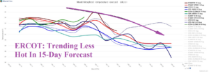
Fig. 1: ERCOT system average temperature forecast through the next 15 days.
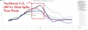
Fig. 2: BPA system average temperature forecast through the next 15 days.
Discussion: Excessive heat continues across ERCOT although forecast models indicate a less extreme heat for the medium range (Fig. 1). Meanwhile, a heat spike across the Northwest U.S. is ahead for next week (Fig. 2) likely extending to California. The heat spike occurs in the 6-10-day period and fades in the 11-15-day timeframe. Currently, excessive heat persists from Texas to Florida (Fig. 3). To the north of the heat dome, an arc of heavy rain causing frequent flash flood risk stretches from the Upper Midwest to the Northeast U.S. through the next 7 days (Fig. 4). The mid-to-late August CDD forecast maintains much above electricity demand trending slightly hooter since yesterday (Fig. 5).
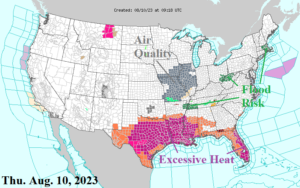
Fig. 3: Latest NOAA/NWS weather watch, warning, and advisory areas.
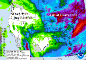
Fig. 4: Arc of heavy rain across the Northeast U.S. in the latest 7-day forecast.
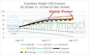
Fig. 5: U.S. population weight CDD forecast utilizing all models, their consensus, comparing with 24 hours ago, and the 10-year/30-year normal.