July 2023 and 2023 (So Far) State Temperature and Precipitation Rankings
08/08/2023, 7:45 pm EDTERCOT Excessive Heat to Ease
08/10/2023, 8:20 am EDTHighlight: ALL CLEAR, no threats through next 2 weeks.
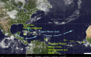
Fig. 1: Satellite view of the North Atlantic basin and primary features.
Today’s discussion: The North Atlantic basin stays ALL CLEAR as tropical waves southeast of the Caribbean Sea and just off the northwest Africa Coast drift westward but do not develop (Fig. 1). An area of thunderstorms south of Western Cuba will weaken. Light shear remains across the Southern Caribbean Sea and east of Puerto Rico. Mid-troposphere relative humidity is very dry across the Gulf of Mexico and western Caribbean Sea suppressing tropical cyclone risk (Fig. 2). There are no obvious and consistent tropical cyclone risks through 15 days (through Aug. 24). Implied are active seasonal tropical cyclone forecasts (Table 1) target SEP/OCT as dangerous.
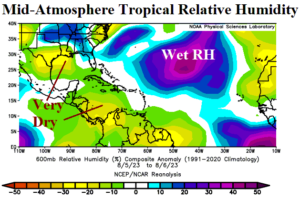
Fig. 2: Mid-troposphere relative humidity anomalies where dry (wet) zones suppress (enhance) tropical risk.
| Climate Impact | Colorado State | T.S.R./U.K. | |
| Tropical Storms (14.4 normal) | 17 (20) | 18 (18) | 18 (17) |
| Hurricanes (7.2 normal) | 6 (9) | 9 (9) | 8 (8) |
| Major Hurricanes (3.2 normal) | 2 (4) | 4 (4) | 3 (3) |
| ACE Index | 114 (160) | 160 (160) | 140 (125) |
Table 1: Latest seasonal tropical cyclone activity forecasts for the North Atlantic Basin with previous forecast in parenthesis.