Consistent Forecast: Europe Turns Wintery Cold Again Mid-February
02/01/2024, 5:30 am EST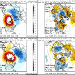
Colder Pattern Change U.S. But Arctic Air In-Doubt For Now
02/06/2024, 8:26 am EST 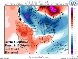
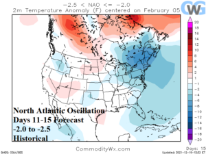
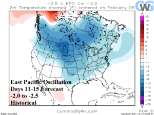
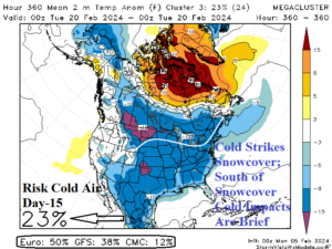
Fig. 1-4: The historical temperature anomaly patterns for current forecasts in the 11-15-day period of the arctic oscillation, North Atlantic oscillation, East Pacific oscillation, and the mega-cluster ensemble strongest cold day-15 forecast.
Discussion: A cross polar arctic outbreak into Canada and the U.S. just-after mid-February remains possible but not a certainty. The CWG/Storm Vista WX Models 0000 GMT climate signal forecasts are supportive of a colder pattern change. Most impressive is the arctic oscillation (AO) with a consensus forecast (by all models) of -3.5 to -4.0 in the 11-15-day period which supports sharp cold from Southwest Canada to the Northeast U.S. although warmer than normal to the south of the cold air mass trajectory (Fig. 1). The -AO forecast is the strongest negative phase of the northern hemisphere winter followed closely by an early December and mid-January peak of near -3.5. The North Atlantic oscillation (NAO) forecast in the 11-15-day period is -2.0 to -2.5 which is second strongest of winter (Jan. 15 was -3.1). The -NAO forecast favors cold in the Northeast U.S. (Fig. 2). The East Pacific oscillation (EPO) used to project “polar vortex” events is forecast -2.0 to -2.5 in the 11-15-day period, similar with polar vortex event of mid-January (Fig. 3). Forecast models generally doubt a major arctic outbreak into the U.S. The coldest possibility is presented by the mega-cluster ensemble rating widespread cold in 15 days (Feb. 20) at 23% risk (Fig. 4). The most likely scenario, given the evidence available, is sharp cold risk to areas with snow cover near the U.S./Canada border east of the Continental Divide. Cold weather traveling south of where snow cover is located is brief and will moderate.
Currently, California is hammered by an “atmospheric river” Pacific storm. Above 4,500 feet the Sierra Nevada will receive 2-4 feet of snow with 5-6 feet in the highest peaks. Southerly wind ahead of the 985 MB coastal low pressure system gust to 65-80 mph. Much of the San Franciso Bay area already has Flood Warning’s issued due to excessive rain. Local NOAA models project 10-15 in. of rain near Wrightwood to the north of Anaheim, CA. The immense storm peaks in intensity and hazards today easing later tonight.
The “atmospheric river” event shifts eastward and weakens this week (Fig. 5) and is followed by a quiet 6-10-day period. In the 11-15-day period, a second “atmospheric river” event slams Mexico and the Southwest U.S. (Fig. 6).
The U.S. gas population weight HDD forecast indicates very low national heating demand into the middle of February followed by above normal demand for Feb. 16-22 and a colder trend since yesterday (Fig. 7). The consensus is in the 195-200 HDD range compared to the 265-270 HDD range for the mid-January arctic outbreak.
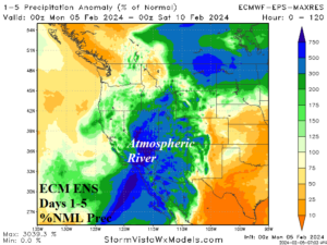
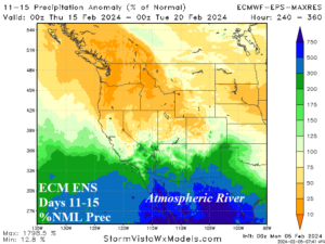
Fig. 5-6: ECM ENS percent of normal precipitation forecast for the 1-5-day and 11-15-day period across the West U.S.
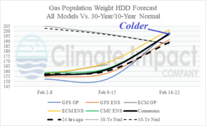
Fig. 7: The U.S. gas population weight HDD forecast utilizing all models, their consensus, and comparing with 24 hours ago and the 10-year/30-year normal.