Shock Cold Next Week and Following Week Based on Today’s 12Z GFS
01/11/2024, 12:43 pm ESTMadden Julian Oscillation To Intensify
01/14/2024, 7:54 pm EST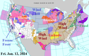
Fig. 1: NOAA/NWS weather watch, warning, and advisory areas.
Discussion: Each of the 50 states has a weather watch, warning, or advisory in effect (Fig. 1). This morning, the main event is a blizzard taking place in the Midwest States centered on Iowa. Blizzard conditions extend to Michigan. An additional 5-15 in. of snow is forecast through tonight with jackpot amount in Chicago (Fig. 2). A Tornado Watch is in effect for Northern Mississippi and Louisiana. Severe thunderstorms featuring tornadic activity regenerates today across Southeast U.S. (Fig. 3). By tomorrow morning, a 970 MB low pressure area is over the northeast Great Lakes. Pressure that low (equivalent to a minimal category-3 major hurricane) is going to force high wind. Right now, wind advisories and warnings extend across almost the entire eastern and southern U.S. A weekend snowstorm moves across the West U.S. while Northern California receives heavy rain, coastal flooding, and high wind. This storm moves across the U.S. into early next week and is followed by an arctic outbreak into the Great Plains. The east-shifting storm brings a Northeast/Mid-Atlantic snow episode next Tuesday (Fig. 4). The U.S. population weight HDD forecast projects a U.S. heating demand spike for next week followed by steady easing toward normal demand into early February (Fig. 5).
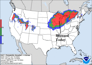
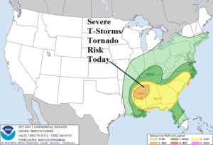
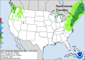
Fig. 2-4: Today’s blizzard and severe weather outbreak areas and Tuesday’s snowstorm projection.
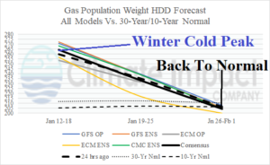
Fig. 5: The U.S. population weight HDD forecast utilizing all models, their consensus, and comparison with 24 hours ago and the 10-year/30-year normal.