All 50 States Have Weather Hazards; Northeast U.S. Snowstorm Next Tuesday
01/12/2024, 9:00 am ESTA Check on Europe HDD Forecasts
01/16/2024, 2:25 pm ESTHighlight: Intense Madden Julian oscillation episode warms the U.S. and Europe ahead.
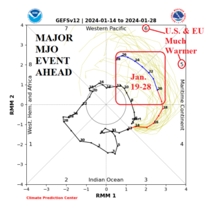
Fig. 1: NOAA/CPC 2-week MJO forecast reveals an emerging and intense phase_5/phase_6 episode during January 19-28.
Discussion: NOAA/CPC indicates an emerging and very intense convection phase of the Madden Julian oscillation (MJO) pushing across Maritime Continent over the next week or so (phase_5) and into the tropical West Pacific (phase_6) by January 23-24 (Fig. 1). During MJO P5 and P6 the mid-latitude Pacific jet stream strengthens and increases mild maritime influence on the North America and Europe climate. Consequently, during the 8-14-day period (Fig. 2) and especially the 11-15-day period, the North America and Europe climate shift out of the current extreme cold and into and extremely mild climate. Additionally, the southern oscillation index (SOI) will shift out of the positive phase as the MJO event described develops and into the negative phase in 10+ days as El Nino 2023-24 has another surge. Long-range MJO forecasts indicate the tropical West Pacific surge weakens moving further eastward which could signal returning cold in February for both the U.S. and Europe.
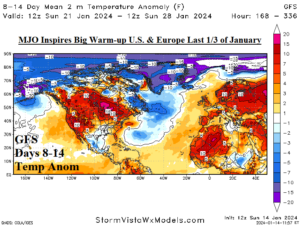
Fig. 2: The GFS temperature anomaly forecast for North America and Europe for the 8-14-day period.