More Severe Weather Ahead for U.S. Crop Areas
05/22/2024, 10:35 am EDT27C SST Threshold for North Atlantic TC Development Ahead of Schedule
05/29/2024, 11:02 am EDTHighlight: NOAA/NHC maintains theme of seasonal TC outlooks…a big season ahead! This year, tracking the warmest SST ahead of hurricanes is most important.
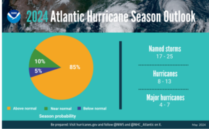
Fig 1: The NOAA/NHC 2024 North Atlantic basin probabilistic seasonal tropical cyclone outlook.
Discussion: NOAA/NHC issued their probabilistic tropical cyclone season activity outlook yesterday. The forecast contains the highest number of tropical cyclone events since NOAA/NHC began issuing seasonal forecasts earlier this century. The outlook indicates 17-25 tropical storms, 8-13 hurricanes, and 4-7 major hurricanes.
The prediction maintains the very active theme of previously issued seasonal forecasts from Colorado State University, Tropical Storm Risk/U.K., and Climate Impact Company all issuing forecasts in early April with updates scheduled for early June.
The very active seasonal forecasts are caused by a record warm North Atlantic surface, particularly in the tropics and subtropics, and anticipated light wind shear in the upper atmosphere of the tropics due to an ENSO shift from El Nino to La Nina.
NOAA/NHC indicates 2 new models, the Modular Ocean Model (MOM6) and SDCON, will improve hurricane intensity forecasts as related to the warmer ocean. This is important as recent years have produced 86-87F/30-31C SST conditions ahead of approaching tropical cyclones and once a system moved across the buoyant warm water intensification to major hurricane status occurred. This condition is most frequently observed in the northwest Caribbean Sea and Gulf of Mexico.
Climate Impact Company will monitor and issue statements on where these exceptionally warm SST are present as they will represent areas where the strongest hurricanes will develop. The 86-87F/30-31C SST appear in the Bay of Campeche in the far southwest Gulf of Mexico first, northwest Caribbean Sea second, and parts of the Gulf of Mexico and possibly the Bahamas last as we move through August and into September.