More Planting Delays Due to Central U.S. Rains and Severe Weather
05/20/2024, 4:28 am EDTNOAA/NHC 2024 Hurricane Outlook
05/24/2024, 4:43 am EDT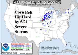
Fig. 1: NOAA/SPC severe weather reports from yesterday (May 21).
Discussion: A major severe weather event struck the U.S. Corn Belt yesterday with nearly 500 severe weather damage reports collected by NOAA/SPC including 23 tornado reports (Fig. 1). Central Iowa to southwestern Wisconsin were the hardest hit. Flooding from excessive rainfall also occurred in this stretch. Today’s severe weather shifts south and is most focused on northern Texas to central Arkansas where an unusual amount of hail is forecast (Fig. 2). Tornado risk is also possible in this sector. Severe storms roll across the eastern Ohio Valley later today. On Thursday, another severe weather episode is likely stretched across the central to southeast Great Plains with primary concern damaging wind gusts (Fig. 3). The Friday strong thunderstorm risk returns to the Corn Belt and an upgrade to severe intensity is possible (Fig. 4). Another major severe weather outbreak, similar with yesterday’s Midwest U.S. outbreak, is forecast for Sunday from Illinois and Indiana to Arkansas (Fig. 5). Medium-range forecasts are not agreeable on whether drier air will generate or more wet weather continues in the Corn Belt and Soybean areas although wetter scenarios are favored given persistence.

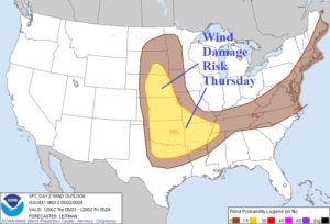
Fig. 2-3: NOAA/SPC severe weather areas for today and Thursday.
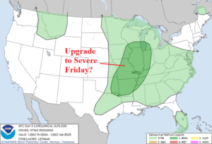
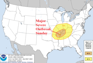
Fig. 4-5: NOAA/SPC strong to severe thunderstorm zones for Friday and Sunday.
An upper trough becomes quasi-stationary across Southwest Europe supporting a heavy rain pattern from U.K. to Northern Italy and into Southeast Europe and Turkey over the next 15 days (Fig. 6). The northern fringe of the wet weather touches far southwestern Russia while areas to the north across the remainder of Southwest Russia is mostly dry (Fig. 7). In the 11-15-day period, AIFS generates very warm temperatures across Southwest Russia (Fig. 8).
The Madden Julian oscillation convection phase shifts across Maritime Continent over the next 2 weeks causing downstream weather pattern adjustments leading to a drier and much warmer regime across South America (Fig. 9-10).
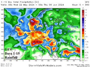
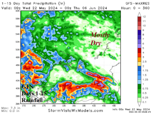

Fig. 6-8: GFS 15-day rainfall forecast for Europe and the Black Sea region plus the AIFS 11-15-day temperature anomaly forecast for the Black Sea region.
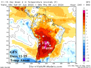
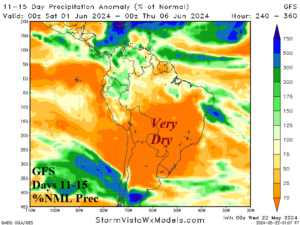
Fig. 9-10: The GFS projects a drier/warmer pattern change in the 11-15-day period.