AI Defeats ECM ENS in 11-15-day Outlook
05/16/2024, 5:32 am EDTMore Severe Weather Ahead for U.S. Crop Areas
05/22/2024, 10:35 am EDT
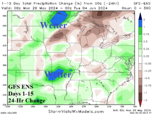
Fig. 1-2: GFS ENS 15-day rainfall forecast across the U.S. AG Belt and the 24-hour change.
Discussion: In the Central U.S., the 15-day forecast trend is wetter. The GFS ENS indicates 3-5-in. rainfall amount across the Upper Midwest and Mid-south States (Fig. 1). Severe weather is involved with the wet forecast and likely forces agriculture delays. The 24-hour change is wetter for both heavy rain regions (Fig. 2). The U.S. soil moisture analysis for May 18, 2024, reveals the weakening drought status across parts of the Central/East-central U.S. (Fig. 3) die to the wet pattern in May which has caused much wetter soil moisture changes (Fig. 4). The wettest changes are in the Gulf States.
In Argentina, a cool month of May shifts cooler in the 6-10-day period (Fig. 5). ECM ENS indicates <32F risk reaches central and eastern Argentina in the 6-10-day period (Fig. 6). The 15-day rainfall forecast is mostly dry thanks to an emerging phase_4 of the Madden Julian oscillation (MJO).
In Western Russia, more chilly weather is ahead centered on the 6-10-day forecast (Fig. 7). However, the risk of <32F stays north of major crop areas (Fig. 8). The 15-day forecast remains very wet over West and South Europe.
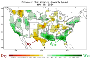
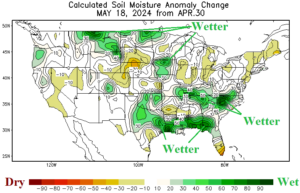
Fig. 3-4: U.S. soil moisture anomalies as of May 18, 2024, and the change in May.
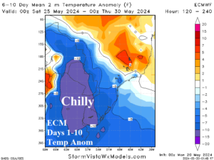
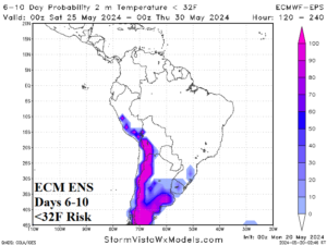
Fig. 5-6: The ECM 6-10-day temperature anomaly forecast across Argentina and the <32F risk.
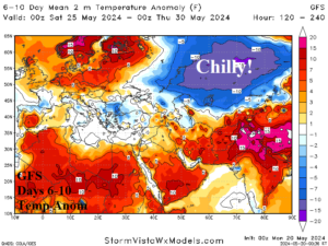
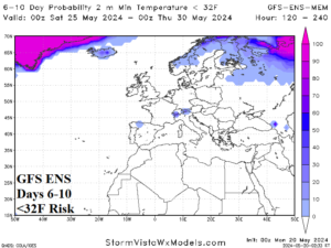
Fig. 7-8: The GFS 6-10-day temperature anomaly forecast across Europe and Western Russia and the risk of <32F.