First Major U.S. Heatwave of Season Ahead for Texas
05/14/2024, 1:40 pm EDTMore Planting Delays Due to Central U.S. Rains and Severe Weather
05/20/2024, 4:28 am EDT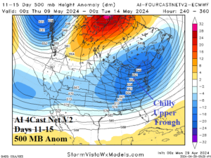
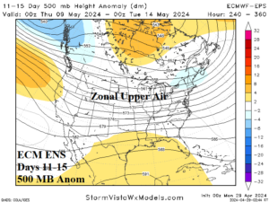
Fig. 1-2: The 500 MB anomaly forecast across the U.S. for May 9-13, 2024, via a 11-15-day outlook by the AI Forecast Net V2 (ECMWF) and ECM ENS.
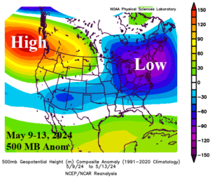
Fig. 3: The 500 MB anomaly observations across the U.S. for May 9-13, 2024.
Discussion: Given the distinct cool West and warm East U.S. temperature signature of meteorological spring 2024 surprising was the sudden amplified upper trough in the East U.S. via an 11-15-day forecast by the AI 4Cast.Net V2 outlook issued on April 28th (Fig. 1). The forecast was completely out of character for the spring season. By comparison, the heavily relied upon ECM ENS upper air forecast indicated zonal (strong west-to-east) flow across the U.S. (Fig. 2). Verification of May 9-13, 2024, upper air pattern using 500 MB anomalies validates the AI forecast as a deep trough formed over the Northeast States (Fig. 3). The transition into the deep upper trough pattern caused excessive rain and severe weather in the Gulf States. Not forecast by either ECM ENS or AI 4Cast.Net V2 was the upper ridge off the Northwest U.S. Coast where anomalous warmth extended from Oregon and Washington to the northern Great Plains.