The Most Reliable U.S. Spring 2020 Flood and Drought Outlook
02/27/2020, 4:50 am EST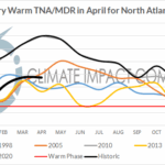
Unique: Very Warm Gulf of Mexico and Tropical North Atlantic Ahead of the 2020 Tropical Cyclone Season
04/19/2020, 9:49 am EDTCoastal Gulf of Mexico drought and early season heat risk
Potential for excessive rainfall events in summer
Potential for rapidly intensifying tropical cyclones
Sea height rise

Fig. 1: The daily sea surface temperature anomaly (SSTA) analysis across the Gulf of Mexico indicates possible record results for late March.
Analysis: The Gulf of Mexico has attained what may be the warmest surface temperatures anomalies on record for late March (Fig. 1). The regional sea surface temperature anomalies (SSTA) is a whopping +1.79C which includes widespread +3C to +5C anomalies across the northern and eastern Gulf of Mexico. The primary contributor to the warming is a strengthening subtropical high pressure area present across the Gulf of Mexico since early winter (Fig. 2) although particularly intense the past 30 days (Fig. 3).
The strengthening subtropical ridge in recent weeks has caused a generally cloud-free weather regime as the early spring sun strengthens causing the rapid warming. Climate effects include the persistent very warm bias to the Southeast and East U.S. and more recently the rapid drying of soil moisture in each Gulf of Mexico state near the coast (Fig. 4).
The warm Gulf surface implies exceptional low atmospheric available moisture. In-between the warm Gulf States climate and the colder regime to the north an intense storm track has emerged this mid-to-late winter and early spring season as deep abundant moisture from the Gulf has enhanced the storm track causing frequent flooding events from the Mid-South U.S. to the Tennessee Valley and into the Interior Southeast States (Fig. 5).
Warm SSTA also imply sea level rise. NOAA analysis indicates a sea level rise of 10-15 CM (4-6 in.) across the north and east Gulf of Mexico (Fig. 6).
Implications: Natural is the emergence of the subtropical ridge across very warm waters of the Gulf of Mexico and western North Atlantic basin compared to the mean upper trough over the much colder wintertime continent to the north. However, as the continent warms with the arrival of summertime the subtropical ridge may have a tendency to also shift north. The warm Gulf of Mexico flips purpose as an enhancing warm climate feature to a potential heavy rainfall catalyst. However, until the pattern-flip the Gulf Coast continues to dry and risk of mid-to-late spring unusual heat continues.
Once the wet influence on the coastal Gulf of Mexico emerges the character of the precipitation is convective, i.e. hit-and-miss. Gully-washer thunderstorms dropping substantial rainfall can occur while other areas stay dry. So the expected heavy rainfall once the warm season arrives is patchy and not widespread.
Of course, the primary concern is significant upper ocean heat to cause tropical cyclones to intensify rapidly. The 2020 North Atlantic basin tropical cyclone season is likely very active due to the warm SSTA pattern in the North Atlantic and an ENSO pattern that is neutral or possibly a weak La Nina. The Gulf of Mexico will be susceptible to unusually strong tropical cyclones if the warm SSTA pattern holds (as forecast by most models).
Finally, the unusual warm SSTA implies rising sea level as already described. Strong onshore wind will bring unexpected flooding spring into summer while flooding associated with tropical cyclone activity approaching/crossing the coast will be made more severe by the already rising Gulf surface.
Regions of warm SSTA are catalysts to unusual climate regimes and high impact weather to the affected communities.


Fig. 2-3: The 90-day and 30-day 500 MB anomalies identify a strong subtropical ridge across the Gulf of Mexico intensifying in March.

Fig. 4: The subtropical ridge across the Gulf of Mexico is drying coastal soils.


Fig. 5-6: The 90-day precipitation anomalies by NOAA/CPC identifies the dry influence of the subtropical ridge on the Gulf Coast while to the north entrainment of abundant Gulf moisture into the prevailing storm track has caused excessive rainfall. The warm SSTA in the Gulf has caused 10-15 CM sea-height rise according to NOAA/CPC.