The Potent Influence and Implications of Warm SSTA on Climate
03/27/2020, 5:08 am EDTDeveloping Deep Layer Soil Moisture Deficit and Late Summer Dryness/Heat Caused Southeast Brazil Flash Drought
04/27/2020, 8:59 am EDT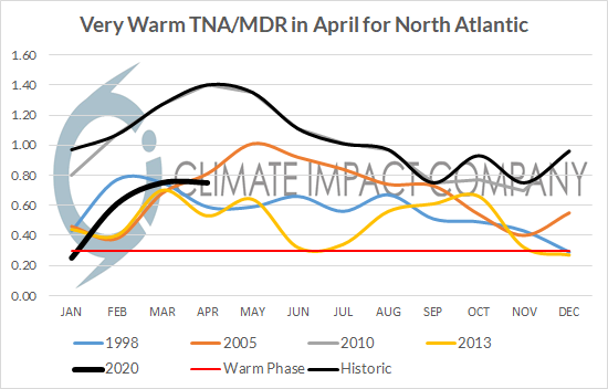
Unique: Very warm Gulf of Mexico and tropical North Atlantic ahead of the 2020 tropical cyclone season.
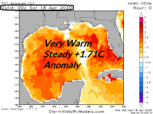
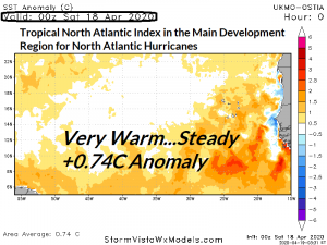
Fig. 1-3: The Gulf of Mexico remains unusually warmer than normal for April while the outer tropical North Atlantic is also very warm as defined by the tropical North Atlantic index which is also the Main Development Region for North Atlantic hurricanes.
Discussion: Of concern regarding predictors of North Atlantic basin tropical cyclone activity is the preseason anomalous warmth of both the Gulf of Mexico and the Main Development Region (MDR) for North Atlantic hurricanes which extends from the eastern fringe of the Caribbean Sea to the northwest coast of Africa also matching the same region where tropical North Atlantic (TNA) index is measured. In the modern-day climate record (past 30 years) the TNA index has been similarly warm in 1998, 2005, 2010 and 2013 during April. Interestingly, none of these analog years co-existed with a warmer than normal Gulf of Mexico. In fact, the GOM was cooler than normal in each of the analog years. The combination of the very anomalous warm GOM/MDR/TNA in April (6 weeks ahead of the onset of tropical cyclone season) is unique and represents abundant near surface/surface ocean heat to propel tropical cyclone intensity. Regarding tropical cyclone activity in the analog years…except for 2013 when a large upper trough formed in the Bahamas during the tropical cyclone season shearing any threatening activity moving toward the U.S. the analog years of 1998, 2005 and 2010 were each dangerously active featuring major hurricanes Georges into Louisiana/Bonnie into North Carolina (1998), numerous GOM major hurricanes (Dennis, Emily, Katrina, Rita and Wilma) in 2005 and another 5 major hurricanes in 2010 (most into or east of the Bahamas).
Conclusions: Unique to 2020, the pre-tropical cyclone season sea surface temperature anomalies (SSTA) are unusually warm in both the Gulf of Mexico and the tropical/subtropical North Atlantic basin in-between the eastern Caribbean Sea and northwest coast of Africa. Implied is abundant (unprecedented?) upper ocean/surface heating to cause passing tropical cyclones to intensify dramatically (assuming the proper upper air patterns). In the modern-day record the years when the warmest tropical North Atlantic index in April was present, the Gulf of Mexico was cooler than normal (until this year). Analog years 1998, 2005 and 2010 were 8th, 1st and 13th most dangerous (using accumulated cyclone energy index). Unless an El Nino is present in 2020 (current forecasts indicate neutral ENSO to La Nina) the upcoming season is likely to rank in the top 25% most active based on the analogs and given the rare combination of both a warmer than normal GOM and MDR ranking in the top 10% most active is a very reasonable assessment.