Marine Heatwave Drives Rio Grande do Sul Extreme Rains
05/02/2024, 8:46 am EDT
Fine Line for Wet Vs. Dry in Central U.S. Summer 2024?
05/14/2024, 6:03 am EDT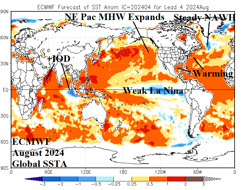
Executive summary: An extremely complicated North Atlantic and Northeast Pacific SSTA regime with profound influence on North America and Europe climate is reviewed. The North Atlantic is record warm but with a unique character and forecast (by ECMWF) to change during the northern hemisphere summer. Similarly, important changes are forecast (by ECMWF) in the Northeast Pacific. There are attendant implications on the tropical Pacific and Atlantic SSTA regimes also contributing to the North America and Europe climate over the next 3-6 months. In summary, the Northeast Pacific marine heatwave regenerates shifting eastward toward the U.S. and increases risk of returning West U.S. drought beginning later this summer season. The profound subtropical/tropical North Atlantic warmth spreads westward to the U.S. East Coast and Gulf of Mexico creating increased risk of a hot summer for the East U.S. while supplying record-strength upper ocean heat for 2024 North Atlantic hurricane season. Finally, persistence of the North Atlantic warm hole during summer 2024 should recreate conditions in the upper atmosphere supportive of a hot and dry ridge in parts of Europe and/or Western Russia during upcoming summer.
Discussion: Since the late 1990’s the North Atlantic has entered a warm cycle as identified by the Atlantic multi-decadal oscillation (AMO). The AMO warm and cool cycles are typically 3-4 decades. The current warm AMO cycle is nearly 3 decades old. The last warm cycle lasted 40 years (1925-1965).
The warm North Atlantic Ocean basin character changed about 10 years ago. The steady warming of the basin, particularly in the northern latitudes, contributed to a warmer polar climate causal to the constricting polar ice cap and speeding the springtime snow and ice melt across Greenland and Northeast Canada. The fresh-water runoff into the North Atlantic to the south of Greenland has caused a semi-permanent stratified upper ocean layer of cool water. This feature is known as the North Atlantic warm hole (NAWH).
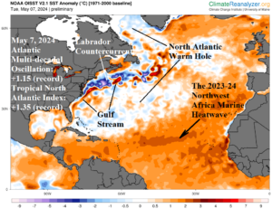
Fig. 1: Daily North Atlantic basin SSTA analysis valid May 7, 2024.
Another change in the North Atlantic basin has occurred during the past 2 years. The NAWH has widened during springtime last year and again in 2024 (Fig. 1) to include areas south and southeast of Greenland extending southwestward to near Bermuda. To compensate, a marine heat wave (MHW) formed off the northwestern coast of Africa last year and remains intense in 2024. The marine heat wave expanded to the North Atlantic subtropics and tropics during the past 8-9 months causing the record warm tropical North Atlantic (TNA) index. The +TNA regime is so warm (+1.35) that the contribution to the entire basin is also causing a record warm AMO (+1.15) for this time of the year.
Meanwhile, the Northeast Pacific contains a similar decade-old basin-wide SSTA pattern character change. About 10 years ago a gigantic pool of warm water (extending to 300-meter depth) formed in the Northeast Pacific and shifted eastward to the North America West Coast causing a major disruption in the ecosystem and El Nino 2015-16 to approach record strength. The MHW became semi-permanent in the Northeast Pacific basin. Recently, the MHW weakened while shifting westward. During recent weeks the MHW has regenerated a vivid presence (Fig. 2) and is beginning to shift eastward again.
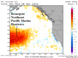
Fig. 2: Daily Northeast Pacific basin SSTA analysis valid May 7, 2024.
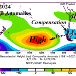
The NAWH and Northeast Pacific MHW semi-permanent presence of the past 10 years has strongly contributed to the shape of the upper air flow across North America and Europe. On average, an amplified high pressure is present near and south of Alaska while a low-pressure area sits southeast of Greenland (Fig. 3). The semi-permanent features identified can meander but are nearly always present. The implications (based on observations) are profound. If the Northeast Pacific ridge expands eastward, strong drought emerges across western North America. When wintertime polar vortex pattern generates, the intensity is extreme and features arctic air. The NAWH trough is compensated for by a downstream Europe ridge responsible for the anomalous warmth of the past decade and increased risk of summer drought.
The SSTA conditions described, especially in 2024, are unique and impossible to analog. Consequently, climate forecasts which are based largely on the global SSTA patterns are forced to recognize the best (model) initialization of current conditions and carry that forecast forward to help project global climate for the remainder of 2024. The best initialization of all models is judged by Climate Impact Company as the ECMWF output.
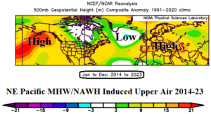
Fig. 3: The 2014-23 upper air pattern across the Northeast Pacific to Western Russia affected by the Northeast Pacific MHW and NAWH SSTA regimes.
In May, ECMWF identifies the emerging MHW in the Northeast Pacific and recognizes the unusually wide influence of the NAWH. These features are affecting the SSTA patterns in the tropics, such as the ENSO regime. Using ECWMF to project the August 2024 global SSTA outlook yields several major regime evolutions.
- A weak La Nina forms. The weak depiction by ECMWF implies a La Nina climate may be slow to develop. Other models, such as CFS V2 are aggressive at developing a stronger La Nina.
- The Northeast Pacific MHW expands toward the U.S. West Coast. The record-length cool phase of the Pacific decadal oscillation (-PDO) is fading. A weakening -PDO is supportive of a weaker La Nina. The risk of high pressure induced hot and dry weather for the U.S. West Coast increases by late summer.
- The NAWH pattern remains vividly present during late summer. The influence on the North Atlantic SSTA is to cause the record warm subtropical/tropical SSTA pattern to spread westward to the North America East Coast. The SSTA pattern surrounding Europe also remains warm. Late summer hot weather risk is evident for the East U.S. and much of Europe.
- In the North Atlantic tropics, the SSTA pattern is record warm and upper ocean heat for hurricanes is immense. This scenario supports record numbers and intensities of hurricanes.
- Finally, presence of a positive phase Indian Ocean dipole (+IOD) is unusual given La Nina expectation. The strong +IOD may be weighing down La Nina development as uniquely forecast by ECMWF. The warm western Indian Ocean guarantees excessive rains for East Africa and northward to possibly include the Middle East.
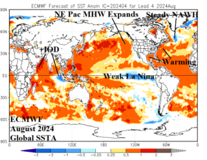
Fig. 4: ECMWF global SSTA forecast for August 2024.
Using ECMWF to project long-term ENSO phase, the model consensus is evolution of a weak La Nina during the JUL/AUG/SEP 2024 timeframe possibly strengthening during northern hemisphere winter 2024-25 and fading toward neutral phase the middle third of next year (Fig. 5). Climate Impact Company agrees with this forecast (based on best initialization of current conditions).
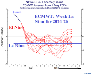
Fig. 5: ECMWF Nino34 SSTA forecast plumes through May of 2025.