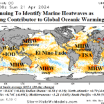
The Influence of Marine Heatwaves on Record Warm Global SST
04/23/2024, 3:58 am EDTFine Line for Wet Vs. Dry in Central U.S. Summer 2024?
05/14/2024, 6:03 am EDTDiscussion: An extreme rainfall event (Fig. 1) has occurred in Rio Grande do Sul in Southeast Brazil leaving thousands homeless, many people killed, and widespread destruction such as washed-out bridges and destroyed homes. The rainfall event is ongoing and additional extreme rain is likely into mid-May. Why?
An offered explanation as a catalyst to this rainfall event is El Nino. That explanation is partially true. The daily Nino34 SSTA is +0.61 still within a weak El Nino threshold. Similarly, the southern oscillation index (SOI) 30-day average is steadily in the -0.60 range which is (also) within the El Nino threshold. However, clearly El Nino 2023-24 is weakening and almost over.
The larger contributor to the Rio Grande do Sul extreme rainfall event is the influence on the subtropical/mid-latitude upper air flow by a South Pacific Ocean marine heatwave (MHW).
In the central Southern Pacific Ocean, a gigantic area of much warmer than normal ocean surface is persisting (Fig. 2). Frequently, referred to as the “New Zealand marine heatwave” this region of anomalous warm water is decadal in timescale often centered on waters surrounding New Zealand sometimes extending eastward across the South Pacific mid-latitudes as observed in recent months.
Long-lasting large areas of anomalous warm water cause the upper atmosphere to warm leading to strong high-pressure ridge areas. In April 2024, an amplified high -pressure ridge crested over the South Pacific to the east of the Dateline (Fig. 3). The atmosphere is in a constant state of balancing. To compensate for the upper ridge, a downstream upper trough formed (and amplified) over Southern Argentina in April. To the north of the Argentina low, additional compensation forms, a strong subtropical high in East-central Brazil.
What does all this mean? Extreme weather! The boundary in-between the Argentina low and Brazil high sustains heavy rain in far Southeast Brazil while to the north, the remainder of Brazil observes worsening drought. To the south, unusually cool weather spreads across Argentina. The GFS 15-day outlook sustains the turmoil into mid-May (Fig. 4).
The incidence of MHW to extreme weather events is clearing increasing.

Fig. 1: The NOAA/CPC 7-day rainfall amount observations reveal heavy (and ongoing) rainfall in Southeast Brazil.
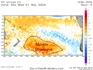
Fig. 2: The daily South Pacific SSTA analysis reveals the presence of a large marine heatwave.
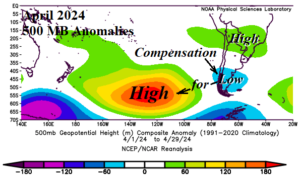
Fig. 3: The 500 MB anomaly pattern for April 2024 across the South Pacific and South America.
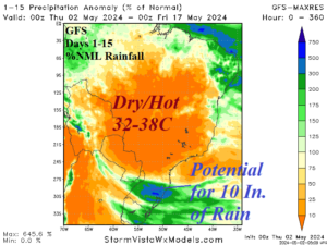
Fig. 4: The GFS 15-day percent of normal rainfall forecast across Brazil and Argentina.