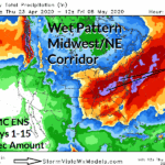
Heavy Rain Set-up for the Midwest/Northeast U.S. Corridor
04/23/2020, 4:38 pm EDTSlow-moving Severe Weather/Excessive Rainfall Event into the East
04/29/2020, 10:45 am EDT
Fig. 1: The Australia Bureau of Meteorology issues a more intense negative phase of the Indian Ocean Dipole earlier today.

Fig. 2: The –IOD pattern will generate a wetter than normal climate across western and southern Australia during winter.
-IOD forecast strengthens/Weak La Nina ahead: The Australia Bureau of Meteorology updated their Indian Ocean Dipole (IOD) forecast earlier today which more aggressively forecasts negative phase for winter/early spring ahead (Fig. 1). The –IOD pattern favors wet climate across western and southern Australia including most crop areas (Fig. 2). Also indicated is a borderline La Nina by July (Fig. 3) a forecast supported by the increasingly cooler subsurface equatorial Pacific Ocean (Fig. 4).

Fig. 3: The Australia Bureau of Meteorology ENSO forecast is updated and indicates weak La Nina by July.

Fig. 4: Subsurface equatorial Pacific Ocean temperatures are shifting cooler and supportive of La Nina later in 2020.