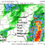
ECMWF Indicates an Atlantic Seaboard Subtropical Storm for Early Next Week
10/18/2022, 10:15 am EDTCIC and NOAA NOV/DEC/JAN 2022-23 Climate Forecast Comparison
10/20/2022, 7:02 pm EDT


Fig. 1-3: Mega-cluster ensemble “most likely” percent of normal rainfall forecast through 15 days for South America.
Discussion: Mega-cluster ensemble is entirely influenced by ECM in the WED-SUN forecast producing more wet weather across Paraguay and into Southeast Brazil (Fig. 1). The areas either side of this wet zone are generally dry. Remember, this (wet) zone was turning very dry this time last year foreshadowing a following drought. In the 6-10-day period, mega-cluster ensemble shifts the wet weather into Northeast Brazil and amplifies the intensity while Southeast Brazil turns dry (Fig. 2). Note the showery regime across Eastern Argentina in the 6-10-day period. ECM also heavily biases the 6-10-day forecast. In the extended range, the mega-cluster returns the wet weather to southwest/southeast Brazil where soils are wet due to rains from the past 3 months (Fig. 3). Usually, large areas of wet soil avoid dry climate during the following summer season, a completely different scenario for this region vs. last year.
In Australia, the rain keeps on coming. The latest ECM 10-day rainfall forecast indicates 3-6 in. of rain across East Australia (Fig. 4). Looking beyond 10 days, the wet pattern is likely to continue. Rainfall amount in the ECM forecast could easily be exceeded in some areas.

Fig. 4: ECM 10-day rainfall forecast for Australia.