Persistent Rains Southwest and Southeast Brazil to Shift Northward
10/15/2022, 9:40 am EDTSouthern Brazil Rains Abate Days 6-10 but Return Days 11-15
10/19/2022, 8:32 am EDT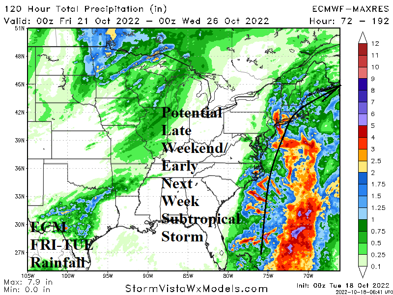

Fig. 1: Latest weather satellite view of the North Atlantic basin.
Discussion: A cold front has entered the waters just-offshore the Atlantic Seaboard and shifting to near the Gulf Stream has caused a massive area of thunderstorms extending from east of Georgia and northward to east of North Carolina. The cold front is pushed eastward by an unusually vigorous upper trough over Ontario the next several days. However, the southern periphery of the frontal zone convenes low-pressure east of the Bahamas Thursday night with an attendant large area of showers and thunderstorms. The area of thunderstorms elongates from just east of the Bahamas toward Bermuda late Friday. By Saturday morning the persistent convection enables an organized low-pressure area to form just to the east of the Northern Bahamas.
Currently, upper shear is extensive in this region. However, the persistent convection should warm the atmosphere and cause the shear to fade by late week. Water temperatures are near 83F/28C which is warm enough for tropical development.
Initially, the developing low-pressure area is likely subtropical in nature. A subtropical depression may form east of the Northern Bahamas on Saturday based on the latest ECMWF forecast. The model projects a subtropical storm slowly moving northward on Sunday to a position due east of Savannah, GA and south-southeast of Cape Hatteras by 2PM EDT on Sunday. At that time gathering wind and rain spreads across North Carolina, Virginia and the Mid-Atlantic Coast. A strong pressure gradient north and west of the storm center is likely to propel tropical storm force wind along the coast on Sunday.
By next Monday morning, this system is just off the Cape Hatteras area and moving north slowly as the veil of attendant heavy rain and tropical storm force wind extends into the northern Mid-Atlantic States and southern New England.
ECMWF indicates this system weakens over cooler waters south of Long Island and moves across southern New England early next Tuesday.
The primary issue with this event is strong high-pressure to the north of what becomes a subtropical storm. The pressure gradient will create a high wind field along the Mid-Atlantic/Northeast Coast causing tropical storm-like conditions including high wind, heavy rain and coastal flooding.
The event begins Saturday night along the Carolina Coast and advances to the Mid-Atlantic Coast on Sunday reaching the northern Mid-Atlantic Coast on Sunday night.
The next storm name is Lisa. This system is likely subtropical in nature and not a full-blown tropical storm. The guidance used is via the ECMWF model which is the most aggressive with this storm potential. The GFS keeps the system farther offshore and weaker.