Brazil and East Australia Rains Ahead; More Arctic Air Northwest Eurasia.
01/01/2024, 3:59 pm ESTHighest Precipitation Probability for Days 6-10 Issued by NOAA/CPC in Memory
01/04/2024, 4:41 am EST 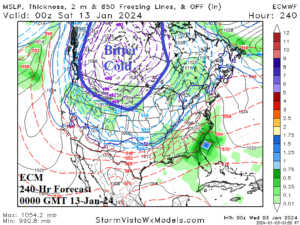
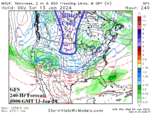
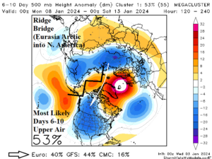
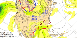
Fig. 1-4: The ECM and GFS 240-hour forecast depicting bitter cold arctic air shifting into the Northern U.S. with a 53% chance of the “ridge bridge” pattern over Alaska driving the arctic air risk. Graph Cast AI does not show the bitter cold risk.
Discussion: The overnight ECM 240-hour forecast is an attention getter. Frigid arctic air is present across the western half of Canada charging into the Northwest and North-central U.S. (Fig. 1). Temperatures average 20F to 40F below normal in this air mass and feature 2-meter temperature forecasts of -40F to -50F in Central Canada with below zero into Wyoming and South Dakota. Meanwhile, the GFS has a much narrower sliver of arctic air in Central Canada extending to the northern Great Plains (Fig. 2). Stratospheric warming to cause arctic air generation near the North Pole is occurring over the next week or so. The arctic air mass generates over Northwest Russia. A “ridge bridge” upper air pattern over Alaska causing a cross-polar surface wind to channel the Russia arctic air into North America is appearing in the 6-10-day period according to the mega-cluster ensemble with a 53% chance of occurrence (Fig. 3). Up until this point (past 30 days or so), the day-10 Graph Cast AI SLP forecast has outperformed ECM and GFS. The Graph Cast day-10 forecast shies away from bringing bitter cold into Western Canada (Fig. 4). The scenario described has VERY serious implications for the U.S. If the ECM (which is generally reliable) is correct, bitter cold risk to the U.S. is present which will include attendant snow AND ice storms on the leaning edge of the air mass. This is also a significant test between NWP-generated forecasts (ECM/GFS) and AI-driven forecasts. Support for the ECM solution is present. Subsequent model runs during today and tomorrow will (hopefully) bring more confidence. The trend is toward the ECM solution and the key diagnostic is presence of the “ridge bridge”.