Warning…ECM Indicates Bitter Cold in 10 Days!
01/03/2024, 5:14 am ESTComparing The Mid-January 2024 Cold With Epic “Uri”
01/05/2024, 9:04 am EST 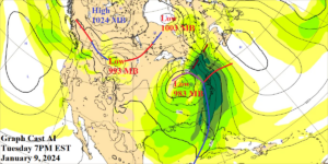
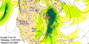
Fig. 1-2: Graph Cast AI-generated forecast model indicates unusually intense rain and windstorms in the East early and late next week.
Discussion: The evolving early-to-middle January 2024 weather forecast features high impact events featuring major storms in the East and arctic air heading into the West. There are important distinctions in the forecasts made between the Graph Cast AI-generated model and the conventional GFS and ECM models. The Graph Cast AI-generated model emphasizes major storms in the East with the first next Tuesday when high wind and heavy rain pounces on the Atlantic Seaboard with snow and ice across the Northern Appalachians (Fig. 1) followed by another similar style storm into the Appalachian Spine very late next week (Fig. 2). Each storm features unusually low pressure (983 and 987 MB) and emphasizes high wind for the Southeast/East States with attendant heavy to extreme rain. Severe thunderstorms are likely in the northeastern Gulf States in this scenario. Note the high pressure on each Graph Cast forecast across the western half of North America peaking at 1026 to 1032 MB in the Jan. 13 forecast. Arctic air features higher pressure as indicated in the Jan. 13 forecast by ECMWF (1043 MB) with an attendant frigid air mass into the West U.S. (Fig. 3). The GFS is not as strong as ECM with the arctic air. The consensus between the models is less emphasis on an arctic air intrusion and increased focus on East U.S. storms. In fact, yesterday’s NOAA/CPC 6-10-day precipitation probability forecast is the strongest wet weather risk forecast by NOAA/CPC in memory (Fig. 4). The U.S. population weight HDD forecast continues to increase U.S. heating demand in the Jan. 12-18 timeframe lead by the CMC ENS and GFS OP models (Fig. 5).
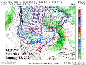
Fig. 3: ECMWF indicates an extremely cold arctic air mass into the Interior West very late next week. The model is much colder in the West and less stormy in the East compared to Graph Cast AI.
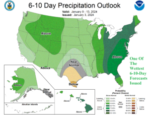
Fig. 4: One of the wettest precipitation probability forecasts in memory was issued for the East U.S. yesterday by NOAA/CPC valid for the 6-10-day period.
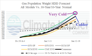
Fig. 5: Operational models are trending colder for Jan. 12-18 lead by CMC ENS and GFS OP.