Ongoing Drought Central Plains, Midwest, and Mid-Atlantic States Greeted With Patchy Rains Next 15 Days
06/11/2023, 1:23 pm EDTRainfall Needed to Neutralize Dry Palmer Drought Severity Index is Increasing Across The Eastern U.S.
06/13/2023, 8:51 am EDT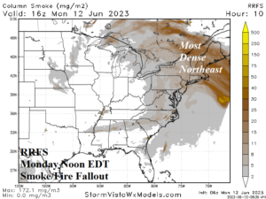
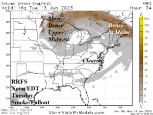
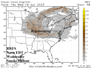
Fig. 1-3: The midday EDT (today through Wednesday) East U.S. haze/smoke forecast using the RRFS model.
Discussion: Smoke and haze from the Canadian Fires fallout continue to inhibit visibility and safe breathing across the northeast quadrant of the U.S. The RRFS model projects the most-dense smoke/haze at midday today across New England (Fig. 1), clearing out of the Mid-Atlantic States tomorrow (Fig. 2), and regenerating in the Midwest States Wednesday (Fig. 3).
The catalyst to the haze and smoke is in Canada. However, the prevailing upper air pattern since May 1st is northwesterly from Canada to the U.S. East Coast driving the fallout southward (Fig. 4) rather than due east if normal zonal westerlies were present (aloft). The northwesterly flow out of Canada is inspired by a persistent upper trough along and just-off the U.S. East Coast since early May (Fig. 5).
The super high-pressure ridge across Canada extending into the Northern U.S. has caused wind aloft (and at ground level) to dip well below normal levels during the past 6 weeks. Both the meridional and especially the zonal wind speed anomalies at 400 MB (23,000 feet) across the U.S. since May 1st are well below normal (Fig. 6-7). An evolving El Nino climate is a contributor although unique SSTA (and climate) conditions off each North America Coast is also contributing.
Using an optimum climate normal (OCN), El Nino climatology, and analogs, the projected near-surface (1000 MB) meridional and zonal wind speed anomalies for July maintain below normal wind speeds across most of the critical SPP region and extending into the Northeast U.S. (Fig. 8-9). The Canadian smoke and haze fallout condition is likely to continue through mid-summer.
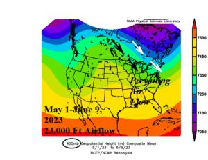
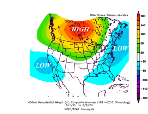
Fig. 4-5: The prevailing upper air wind flow pattern across North America since May 1st and the attendant upper ridge/trough anomalies.
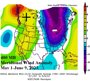
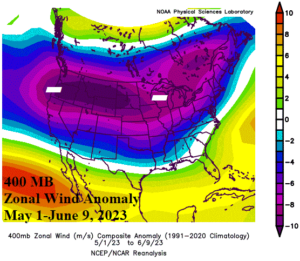
Fig. 6-7: The upper air (400 MB) meridional and zonal wind speed observations indicate the wind aloft is much lighter than normal.
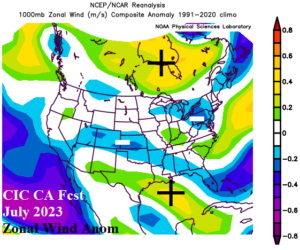
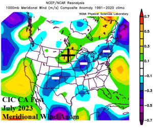
Fig. 8-9: Climate Impact Company constructed analog forecast of zonal and meridional wind speeds for July 2023.