North Atlantic Warm Hole Is Catalyst to Midwest Drought Development/East U.S. Cool Bias
05/31/2023, 2:13 pm EDTNorthwest Air Flow Out of Canada Continues to Push Smoke and Haze Into Northeast U.S.
06/12/2023, 3:17 pm EDT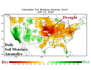
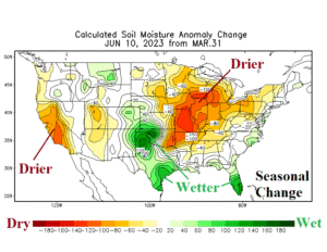
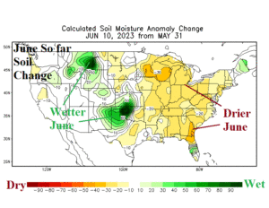
Fig. 1-3: U.S. daily soil moisture anomalies, seasonal, and June change.
Discussion: The daily soil moisture anomaly analysis across the U.S. reveals continuing drought conditions across the central Great Plains, Midwest, and Mid-Atlantic regions (Fig. 1). Since March 31st, the drought condition has worsened while the southwest flank of the Great Plains into Texas has weakened (Fig. 2). So far in June, the entire eastern half of the U.S. has observed a drier soil moisture trend while the erosion of the southwest Great Plains drought has continued (Fig. 3). Of interest is an excellent projection of arid atmosphere/soil moisture conditions across Canada by the evaporative drought demand index (EDDI) leading into the Canadian fire season and the persistence of those conditions in Canada spreading to the Midwest U.S. to the Northeast U.S. Corridor States (Fig. 4). The EDDI analysis reveals the resistance to weakening drought across the northeast quadrant of the U.S. The Far Northwest States are also very dry.

Fig. 4: The most recent evaporative drought demand index (EDDI) analysis.
The latest North America rainfall outlooks extending to late June utilize the most recent mega-cluster ensemble due to the variability of each model. In the 1-5-day period, significant rain followed by cooler temperatures is indicated to start the week across the central and eastern Ohio Valley while areas to the west are mostly dry (Fig. 5). In the 6-10-day period, the preferred rainfall forecast indicates a showery pattern along the northern edge of an emerging hot Texas ridge pattern which affects the Great Plains and Midwest States (Fig. 6). The convective nature of this activity implies some locations receive plenty of beneficial rain while most areas miss rainfall. In the 11-15-day period, the preferred outlook is warmer and mostly dry (Fig. 7).
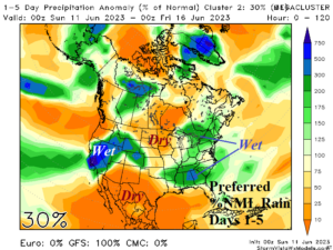
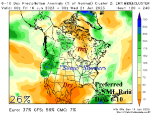
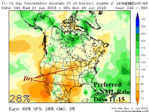
Fig. 5-7: The preferred percent of normal rainfall forecasts for North America through the next 15 days utilizing the mega-cluster ensemble.