Midday 12Z GFS Unloads >12 In. of Rain California and Alabama
02/28/2024, 12:53 pm ESTPolar Ice Cap Continues Well Below Normal
03/01/2024, 1:19 pm EST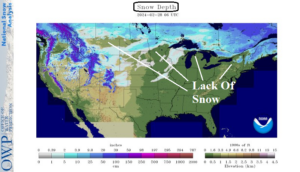
Fig. 1: Snow depth across the U.S. indicates lack of snow east of the Divide.
Discussion: The warm El Nino winter has caused a lack of snowfall east of the Continental Divide. Currently, due to another temperature spike, most areas across the Northern U.S. east of the Divide have no snow especially the central and eastern Great Lakes region (Fig. 1). Only parts of the Upper Midwest and northern half of New England have reasonable snow cover. The historic Smokehouse Creek fire in northwest Texas raises the question of soil moisture as meteorological spring is about to start. The U.S. Drought Monitor identifies all of New Mexico and west/southwest Texas as critically dry areas (Fig. 2). Parts of the Midwest, Upper Midwest, and Montana are also critically dry. The 30-day percent of normal precipitation observations across the U.S. identify classic late winter El Nino conditions with heavy precipitation across California to Arizona, the western Great Plains, and Mid-south States while areas not affected by the precipitation are generally quite dry including Western Texas and the North-central U.S. (Fig. 3). Long-term drought concerns in the U.S. identified by the (experimental) long-term multi-indicator drought index which combine both short and long-term (up to 5 years) precipitation trend and water from snowmelt include the 4-Corners region including the Texas Panhandle, the U.S. Corn Belt, southern Mississippi Valley, and the Northwest U.S. (Fig. 4).
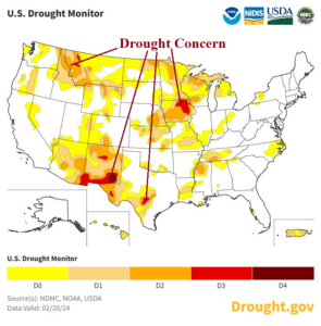
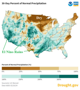
Fig. 2-3: NOAA U.S. Drought Monitor and 30-day percent of normal precipitation across the U.S.
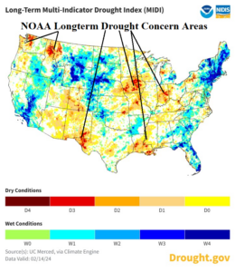
Fig. 4: NOAA long-term multi-indicator drought index identifying drought concern areas ahead.