Marine Heatwaves And East Australia Heavy Rains
01/03/2024, 12:44 pm ESTMadden Julian Oscillation Inspires Atmospheric River Storm Track To Develop
01/21/2024, 11:40 am ESTHighlight: Current assessment of next week’s arctic outbreak.
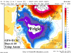
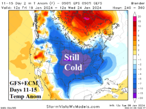
Fig. 1-2: The 12Z GFS+ECM temperature anomaly forecast for the U.S. during the 6-10-day and 11-15-day period.
Discussion: Digesting the midday forecast models leaves a GFS and ECM combination of very cold temperatures in-between the Rocky Mountains and Appalachian Spine in the 6-10-day period (Fig. 1) with a slightly less amplified intensity in the 11-15-day period (Fig. 2). As promised yesterday, a robust convection phase of the Madden Julian oscillation (MJO) shifts into the tropical West Pacific (Fig. 3) just-after mid-month causing a warming influence to develop on the U.S. climate. Snow cover slows the warm-up in the medium range but note the mega-cluster ensemble “most likely” upper air forecast dissipates the polar vortex and creates high pressure across much of the U.S. in 15 days (Fig. 4). Forecasts have shifted colder the past 2-3 days due to a more certain large aerial coverage of snow cover (Fig. 5). The snow cover enhances the cold air mass while preventing much moderation once the air mass shifts south of snow cover. The 12Z ECM indicates snowfall with the arctic front early next week extends farther south than GFS to include Oklahoma/Arkansas (Fig. 6). The farther south snow cover puts the Gulf States in increasing jeopardy of harsh cold next week. ECM indicates the coldest two mornings in the Gulf region are next Tuesday and Wednesday (Fig. 7-8). Dallas plummets to 11F Tuesday morning while Corpus Christi is 25F followed by -8F in Little Rock and 15F in Atlanta Wednesday morning. Note -14F in Chicago next Wednesday morning. The core of the arctic cold will regenerate near Chicago late next week. Unclear is the southern extent of the arctic air into next weekend. However, one risk that is increasing at that time is the emergence of possible sleet, snow, and ice in northern Texas/Louisiana for FRI/SAT Jan. 19-20, 2024. Of course, this entire mess is caused by a stratospheric warming event that caused the second arctic air mass of winter 2023-24 so far across Northwest Eurasia (Fig. 9). A “ridge bridge” of high pressure over Alaska is forecast to develop which reaches cross polar to grab the arctic air and shift the air mass through the polar region and into North America to deepen the polar vortex (Fig. 10).
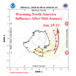
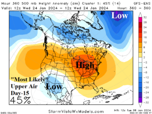
Fig. 3-4: After mid-January, a robust MJO signal across the West Pacific tropics becomes a warming influence on the U.S. and by day-15 the polar vortex is replaced by high pressure.
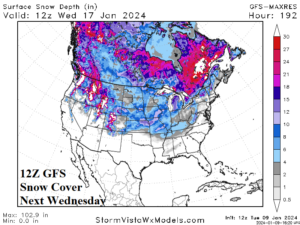
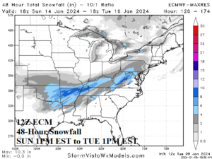
Fig. 5-6: The 12Z GFS indicates the farthest south snow cover valid next Wednesday while the 12Z ECM indicates a snowfall event early next week could push snow cover farther south (enabling a colder Gulf region).
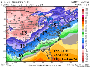
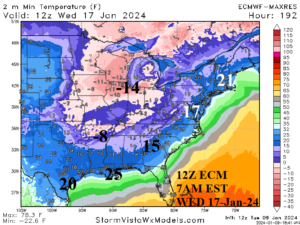
Fig. 7-8: The 12Z ECM minimum temperature forecast for next TUE and WED morning.
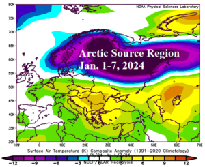
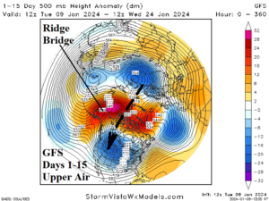
Fig. 9-10: The arctic air reservoir is in Northwest Eurasia now and is expected to travel cross polar enabled by a “ridge bridge” of high pressure over Alaska much of the next 2 weeks.