Hotter Than Normal MAY-SEP U.S. CDD Forecasts
03/19/2024, 12:48 pm EDTEl Nino Hanging On Despite Cooling Subsurface
03/25/2024, 10:34 am EDTExecutive Summary: The Australia season 1-4 ahead outlook is update. The forecast is based primarily on an expected phase change of both the ENSO and IOD regimes plus the influence of marine heat waves on climate. The overall theme of the outlook is wetter as the 2020-22 wet climate across much of Australia returns for 2024.
Summer 2023-24 review: As expected and fueled by the positive phase of the Indian Ocean dipole (+IOD), the western half of Australia was hotter than normal during summer 2023-24 (Fig. 1). Not expected was anomalous wet climate affecting Northern Australia and parts of interior East Australia (Fig. 2). The Climate Impact Company summer 2023-24 climate forecast for Australia issued last September (Fig. 3-4) featured widespread anomalous heat with mostly dry conditions and increased drought risk centered on the north/northwest and east-central continent. The catalysts for the hot and dry forecast were the combination of the +IOD climate and ongoing El Nino. However, a recent tendency affecting global climate, the emergence of large marine heat waves, played a significant role in shaping the Australian summer climate. The upper air pattern featured a semi-permanent upper-level low pressure area centered on the central south coast of the continent (Fig. 5). The upper-level feature helped to induce a wet monsoon over the north and northeast and occasionally invited the attendant moisture southward reaching Victoria. The upper-level low was induced in-between strong high-pressure areas located across vast marine heat waves (MHW) southwest of Australia and in the vicinity of New Zealand (Fig. 6).
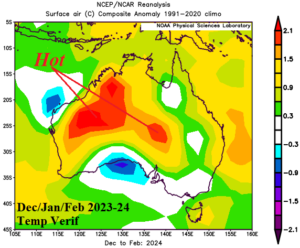
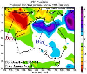
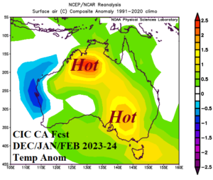
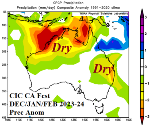
Fig. 1-4: The observed meteorological summer 2023-24 temperature and precipitation anomalies across Australia (upper) compared with the Climate Impact Company forecast issued last September (lower).
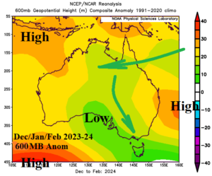
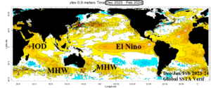
Fig. 5-6: The meteorological summer 2023-24 observed 600 MB anomaly pattern across Australia and the DEC/JAN/FEB 2023-24 global SSTA verification.
Climate 2024-25 outlook: The upper ocean heat in the equatorial Pacific near and east of Dateline is diminishing rapidly foreshadowing an ENSO phase change ahead. The Climate Impact Company constructed analog forecast indicates neutral ENSO by MAY and La Nina by AUG with strengthening La Nina later this year (Fig. 7). A strong +IOD during Q4/2023 ended in February and a rapid trend toward -IOD has eased during the past few weeks. However, based on the North America Multimodal Ensemble (NMME) global SSTA forecast valid for AUG/SEP/OCT 2024, a complete reversal of IOD and ENSO (to the negative phase) is anticipated (Fig. 8). The Climate Impact Company constructed analog forecast of the IOD pattern favors neutral phase ahead with about a 33% chance of the negative phase (Fig. 9). Additionally, note that MHW episodes are present southwest of Australia and in the vicinity of New Zealand plus northwest of Australia associated with the developing -IOD regime. The gathering of warm SSTA to the waters surrounding Australia should produce a wetter climate pattern.
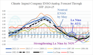
Fig. 7: The Climate Impact Company constructed analog forecast of ENSO phase through DEC/JAN/FEB 2024-25.
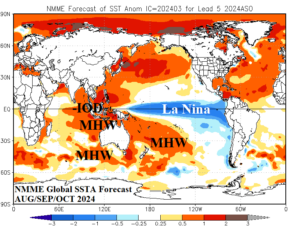
Fig. 8: The NMME global SSTA forecast for AUG/SEP/OCT 2024 with annotated areas of prominent influence on Australia climate.
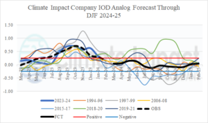
Fig. 9: The Climate Impact Company constructed analog forecast of IDO phase through DEC/JAN/FEB 2024-25.
Forecast methodology: The Australia season 1-4 ahead outlook is based on a constructed analog accounting for historical climate during El Nino to La Nina transition, neutral IOD to -IOD transition (through late year), and the increasing fluence of the past 10 years of MHW episodes.
MAR/APR/MAY 2024: During meteorological autumn, warm SSTA are forecast to emerge to the north and northeast of Australia associated with the onset of an El Nino to La Nina transition. Later in the season, emerging anomalous warm SSTA northwest of Australia is expected. The warming is associated with the onset of a new marine heat wave and eastward shift of the Indian Ocean dipole (IOD). The nearby warming oceans support a wetter climate pattern, especially in the East. Much of the continent is warmer than normal during the season with significant cool treats holding off until May across southern continent.
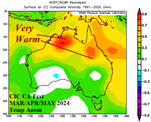
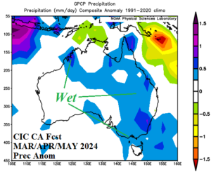
Fig. 10-11: The Climate Impact Company constructed analog temperature and precipitation anomaly climate forecasts for MAR/APR/MAY 2024.
JUN/JUL/AUG 2024: During the winter season, the prevailing upper air pattern features a semi-permanent low-pressure trough most-focused on Southwest Australia. An upper ridge associated with the New Zealand marine heat wave “ridges” westward into Queensland. The sensible weather favors moderate warm anomalies across the northern tier of the continent due to the high-pressure ridge. Southern continent is trending cooler and close to normal. The tendency for above normal precipitation remains across the eastern third of the continent.
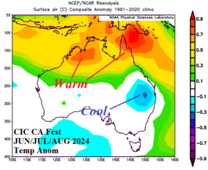
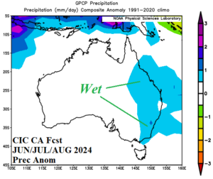
Fig. 12-13: The Climate Impact Company constructed analog temperature and precipitation anomaly climate forecasts for JUN/JUL/AUG 2024.
SEP/OCT/NOV 2024: An impressive upper trough is projected across the southern 2/3 of Australia during meteorological spring. Consequently, most of the continent is cooler than normal except for the northern coastal areas. East Australia continues wetter than normal. The forecast is reasonably similar to the previous projection.
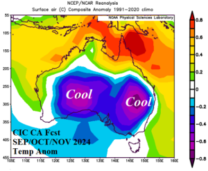
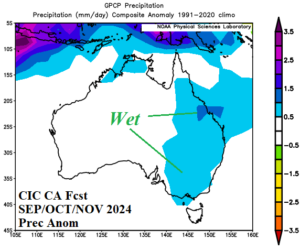
Fig. 14-15: The Climate Impact Company constructed analog temperature and precipitation anomaly climate forecasts for SEP/OCT/NOV 2024.
DEC/JAN/FEB 2024-25: The meteorological summer 2024-25 season does not indicate any anomalous heat. Most of the continent will average cooler than normal due to a persistent upper trough. The precipitation outlook favors a wetter than normal Northern Australia Monsoon.
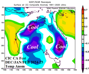
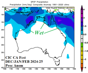
Fig. 16-17: The Climate Impact Company constructed analog temperature and precipitation anomaly climate forecasts for DEC/JAN/FEB 2024-25.