Australia Climate Likely to Shift Back into Wetter Regime of Early Decade
03/25/2024, 6:02 am EDTReworking North Atlantic Basin Seasonal Tropical Cyclone Climatology
03/27/2024, 10:33 am EDT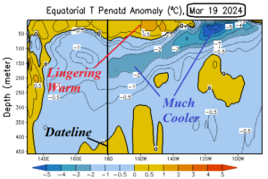
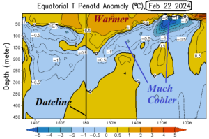
Fig. 1-2: Subsurface temperature anomalies across the equatorial region of the Pacific Ocean.
Discussion: Most instructive regarding ENSO is the current upper ocean heat analysis and comparison with one month ago (Fig. 1-2). Note that the most recent analysis yields a sharp cool (blue) anomaly in the eastern equatorial Pacific off the northwest coast of South America. Westward toward the Dateline, an area of shallow anomalous warmth lingers able to sustain El Nino. Note the one-month trend is steadily cooler favoring weakening of El Nino and increasing risk of following La Nina. At the surface, the Nino4, Nino34, and Nino3 SSTA regions in the central and east-central equatorial Pacific each warmed slightly last week (Fig. 3). The warming was in response to temporary weakening of trade winds preventing the upwelling of cooler subsurface water caused by a eastward shift of the Madden Julian oscillation (MJO). Note that the Nino12 SSTA region has shifted cooler than normal. The NCEP CFS V2 remains aggressive with a La Nina projection for later this year. La Nina onset occurs in May with strengthening by August (Fig. 4). The NCEP CFS V2 La Nina forecast is the most aggressive among all models.
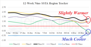
Fig. 3: The Nino SSTA 12-week monitor indicates steadily weakening El Nino although slight warming last week while waters off South America were cooler.
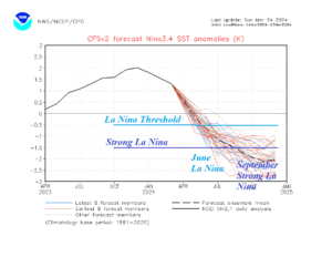
Fig. 4: The NCEP CFS V2 Nino34 SSTA forecast valid through January 2025.