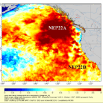
Updating The North Pacific “Warm Blob” and Explaining Optimum Climate Normal
10/26/2022, 5:00 am EDTHow to Break a Long-term Northern half of California Drought
12/30/2022, 11:48 am ESTExecutive summary: Climate Impact Company frequently identifies the Northeast Pacific marine heat wave (“warm blob”) and more recently the North Atlantic warm hole (NAWH) as regional SSTA having a profound influence on atmospheric circulation affecting North America and Europe climate. In the current American Meteorological Society Journal of Climate, research identifying and explaining the marine heat wave off the East Asia Coast and the attendant dramatic influence on East Asia climate was published. New to the oceanic global climate influencers are these large areas of anomalous warm and cool zones, part of climate change, that help to explain unusual climate patterns and help to predict future dramatic climate regimes. Added to the list, is the marine heat wave east of Argentina which in November 2022 is strengthening.
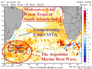
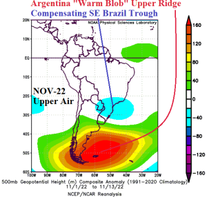
Fig. 1-2: Emerging marine heat wave east of Argentina and the correlating November 2022 (so far) upper air pattern.
Discussion: The marine heat wave east of Argentina, also referred to as the Argentina “warm blob” is vividly identified in the daily South Atlantic SSTA analysis (Fig. 1). The upper air pattern for November 2022 (so far) identifies the correlation of these warm oceanic zones to upper-level high-pressure ridging amplified along the Argentina Coast (Fig. 2). The warm SSTA region is gaining strength (Fig. 3) and 15-day forecasts maintain the upper-level ridge pattern east of Argentina heading toward the start of meteorological summer (Fig. 4).
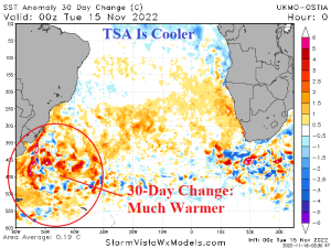
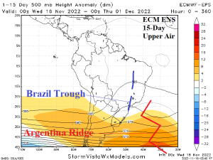
Fig. 3-4: The 30-day SSTA change across the South Atlantic basin and the ECM ENS 15-day upper air forecast.
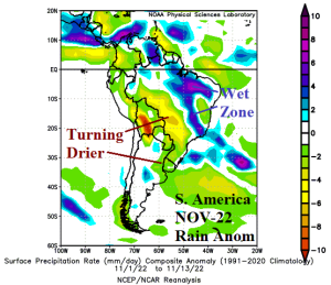
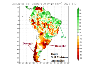
Fig. 5-6: The precipitation anomalies across South America in November so far and the daily South America soil moisture analysis.
The evolving upper ridge is causing the November 2022 precipitation climate pattern to turn drier in Southern Brazil (Fig. 5) as the wet spring pattern in this location is clearly abating. A dry spring across Argentina has already caused dry soils and drought for that zone (Fig. 6). Climate Impact Company projects the dry pattern in Argentina to expand northward during the summer 2022-23 season.
Note that to the north of the warmer than normal oceans east of Argentina, an area of cooler (near normal) SSTA is present off the Brazil Coast. Also note the persistent upper-level low-pressure trough just west of the cooler SSTA zone over southeast Brazil during November (so far). The 15-day outlook identifies the presence of this upper trough maintain that position and causing wet weather across eastern and northern portions of Brazil (Fig. 7). So…while Argentina dryness is likely to spread north, a wet pattern across north and east Brazil is not far away and likely sustained into the approaching summer season.
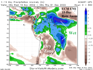
Fig. 7: The ECM ENS 15-day rainfall anomaly forecast across South America.
Summary: The strengthening “warm blob” of SSTA to the east of Argentina is well-correlated to anomalous high-pressure ridging aloft. At times, that high-pressure influence causes dryness and anomalous heat in Argentina likely to expand northward into Southern Brazil during the summer season. To compensate for the upper ridge, a wet low-pressure trough (correlated to slightly cool SSTA east of Brazil) is also likely to persist and cause a wet pattern for north and east portions of Brazil into the summer 2022-23 season.