Updating Global SSTA, Soil Moisture and November 2022 Global Climate Expectations
10/23/2022, 1:12 pm EDTArgentina Marine Heat Wave Influencing South America Climate
11/16/2022, 4:55 am EST
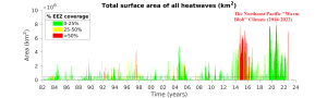
Fig. 1: NOAA/SFSC identifies presence of Northeast Pacific “warm blob” episodes from 1982-2022.
Discussion: The Marine Heat Wave Tracker is a monitoring system developed by the NOAA Southwest Fisheries Science Center. The initial intent was to identify, quantify and explain the 2014-2016 sudden shallow and deep layer anomalous warm ocean water located in the Northeast Pacific (Fig. 1). Since the initialization of the Northeast Pacific “warm blob” in 2014-2016 a semi-permanent character of this oceanic feature has evolved. The correlation to 500 MB heights is astounding and influence on northern hemispheric climate during 2014-2022 unique and potentially identifying this period as an optimum climate normal (OCN). While a typical climatology is based on the average weather of a 30-year period, sometimes climate patterns of much shorter duration are generated in which short-term weather regimes are somewhat different than the standard 30-year climatology. The Northeast Pacific “warm blob” regime of 2014-2022 has caused an OCN to form.
The latest “warm blob” is impressive! NEP22A formed in January 2022 and has reached an intensity and aerial coverage justifying the 4th strongest “warm blob” in the 1982-2022 climatology according to NOAA/SFSC (Fig. 2). A second “warm blob” is located off the southwest California Coast (NEP22B).
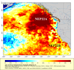
Fig. 2: NOAA/SFSC identifies the Northeast Pacific SSTA regime for October 23, 2022, identifying the “warm blob” NEP22A and NEP22B.
During 2014-2021 when the Northeast Pacific “warm blob” is semi-permanent, the upper air pattern across the North and Northeast Pacific has featured a persistent well-amplified semi-permanent high-pressure ridge (Fig. 3). To compensate for the upper-level high-pressure ridge, a downstream trough has emerged typically positioned over Central Canada. The semi-permanent character of these two upper air features caused an increase in long-term drought strength for the U.S. West Coast, particularly California and the susceptibility to “polar vortex” weather events such as sharp winter cold outbreaks. The 2022 northern hemisphere upper air pattern has generally maintained 2014-2021 features (Fig. 4).
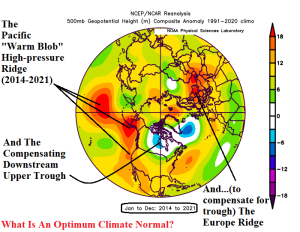
Fig. 3: The 500 MB anomalies across the northern hemisphere for 2014-2021 identifying the presence of the semi-permanent Northeast Pacific ridge and downstream central Canada trough identifying an optimum climate normal.
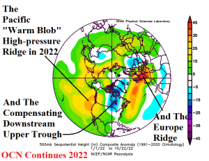
Fig. 4: The 2014-2021 northern hemisphere upper air pattern is maintained in 2022 based on 500 MB anomalies.
Not identified in this report is the presence of the semi-permanent North Atlantic warm hole (NAWH) which is an area of cool SSTA south and southeast of Greenland generally present since 2014. Aloft, a semi-permanent upper-level low-pressure trough has formed across this cool water zone and is compensated for by a persistent upper-level high-pressure ridge over Europe which helps to explain the tendency for warmer and drier than normal climate risk in Europe the past near-decade. The trough/ridge pattern described over the North Atlantic and Europe may be linked to the Northeast Pacific “warm blob” climate. The persistent 2014-2022 northern hemisphere climate pattern is considered (by Climate Impact Company) as an OCN regime.
Based on the 2014-2022 OCN, minus El Nino winter seasons, the VERY likely prevailing upper air pattern across North America for upcoming meteorological winter features the “warm blob” ridge in the Northeast Pacific and a downstream “polar vortex” centered on Western Canada (Fig. 5). Western Canada will experience above normal snowfall and periods of extreme cold during upcoming winter. This location becomes a source region for anomalous chill and possibly arctic air during winter 2022-23. Occasionally, the cold air surges into the U.S. and based on the positioning of the polar vortex is most likely to target the Interior West and Central U.S.
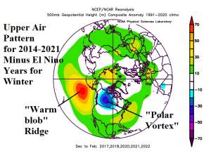
Fig. 5: Based on the Northeast Pacific-inspired OCN, the most likely upper air pattern for North America for upcoming meteorological winter is indicated.