Argentina Marine Heat Wave Influencing South America Climate
11/16/2022, 4:55 am EST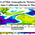
Explaining The “Atmospheric River” Evolution Into California
01/17/2023, 4:16 am ESTDiscussion: Remarkably, a shift from one dramatic weather pattern (Alaska “ridge bridge” and attendant U.S. arctic outbreak) to a completely different but just as hostile regime (Aleutian Low made stronger by a transient tropical MJO) is underway to initiate the ending of a long-term California drought. The 15-day CMC ENS precipitation amount forecast indicates much greater than 12 in. of water across parts of British Columbia and Washington and the San Francisco Bay Area plus the Sierra Nevada (Fig. 1). NOAA/WPC forecasts suggest the likelihood of >20 in. of water in these favored areas particularly in California. The Gulf States and East Coast can also expect 3-8 in. of rain over the next 15 days (Fig. 2).
The catalyst is an energetic jet stream clocking wind speeds of up to 212 mph at times during the next 15 days across the Pacific basin (Fig. 3). The fast jet stream is intense due to the location in-between a super strong Aleutian low-pressure trough and subtropical high-pressure area near and west of Hawaii. The fast jet stream propels storms across much warmer than normal ocean water (Fig. 4). The warmer than normal waters increase evaporation rates to make storms stronger.
Also making storms stronger is the steady increase in MJO presence. Currently, the MJO is in the tropical West Pacific (Fig. 5) but shifts east to rivers of tropical moisture into the Pacific storm track (Fig. 6-7). Short-term forecasts for the West U.S. are prohibitively wet (and snowy). Increasing MJO influence propels stronger storms in the medium range. There’s no question this combination of climate diagnostics will submerge California in heavy rain and mountain snow smashing the long-term drought.
The U.S. soil moisture analysis already reveals a much wetter change for December (Fig. 8-9) across California which will intensify and widen during January!

Fig. 1: CMC ENS 15-day precipitation amount forecast across the West U.S.

Fig. 2: CMC ENS 15-day precipitation amount forecast across the East U.S.

Fig. 3: CMC ENS 15-day upper air forecast across the Pacific basin.

Fig. 4: The daily sea surface temperature anomaly analysis across the Pacific basin.

Fig. 5: The CMC ENS depiction of tropical rainfall identifying presence of the Madden Julian oscillation for the 1-5-day period.

Fig. 6: The CMC ENS depiction of tropical rainfall identifying presence of the Madden Julian oscillation for the 6-10-day period.

Fig. 7: The CMC ENS depiction of tropical rainfall identifying presence of the Madden Julian oscillation for the 11-15-day period.

Fig. 8: Current U.S. soil moisture anomaly analysis.

Fig. 9: U.S. soil moisture anomaly change for December 2022.