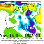
Why Is Eastern Australia Wet During The 2023 El Nino?
12/17/2023, 12:17 pm EST
A Short Summary of AI in Weather Prediction and Its Use as a Tool for Forecast Development
12/27/2023, 3:29 am EST
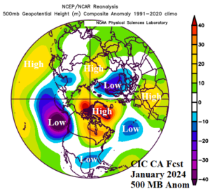
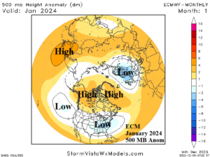
Fig. 1-2: The Climate Impact Company constructed analog 500 MB anomaly projection for January 2024 compared with the ECMWF forecast.
Discussion: The most prominent 500 MB anomaly feature across the northern hemisphere during the second half of 2023 is a vigorous low-pressure trough across Northwest Eurasia compensated for by a broad ridge stretching from Southwest Europe to Kazakhstan. Both the Climate Impact Company constructed analog (CIC-CA) and ECMWF 500 MB anomaly forecasts for January 2024 maintain the Northwest Eurasia trough and amplify this feature to push the Southern Europe ridge farther south. If the upper trough can widen snow cover, cold weather risk for Europe toward the Black Sea region increases. The CIC-CA projection indicates a stronger negative North Atlantic oscillation (-NAO) compared to ECM, therefore a stronger cold risk for Europe. CIC-CA and ECM are agreeable on the Southeast U.S. trough, a common mid-winter feature during El Nino. This feature generates a stormy Southeast/East U.S. regime eventually generating enough cold air to cause significant snow in the Appalachian States. The CIC-CA forecast is stronger than ECM with a low-pressure area in the Northeast Pacific. This feature is in response to an amplified ridge near and east of Japan across a large marine heatwave (MHW). If the CIC-CA forecast is correct, the beginning of a weakening El Nino should initiate as cooler waters are propelled southwestward by the California Current toward the tropics. Additionally, the CIC-CA forecast renders a stormy West Coast for mid-winter (especially California). Both forecasts yield a weak low-pressure trough for Interior East Asia. The CIC-CA forecast is based primarily (although not exclusively) on regional SSTA. Prominent features from the current global SSTA analysis from NCDC/PSD affecting the climate and projected climate for January 2024 are El Nino, marine heatwaves east of Japan and off the northwest coast of Africa plus the redeveloping North Atlantic warm hole (NAWH) well south of Greenland.
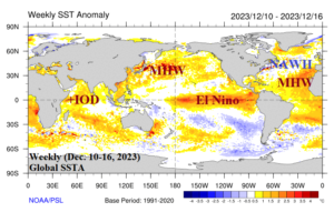
Fig. 3: The weekly (Dec. 10-16, 2023) global SSTA analysis identifying primary regional SSTA regimes.