Onset of +IOD Pattern Helps Maintain Dry India Climate
08/18/2023, 12:14 pm EDTEl Nino Steadily Strengthening
08/21/2023, 1:39 pm EDT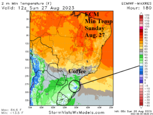
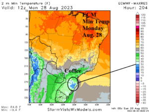
Fig. 1-2: The ECM minimum temperature forecast for SUN/MON Aug. 27-28 indicates nearby (to coffee crop) 32F/0C chill.
Discussion: A thunderous negative phase of the Antarctic oscillation (-AAO) also referred to as Southern Annular Mode (SAM) is present in the southern hemisphere. The result is uncharacteristic deep upper troughs in the southern hemisphere middle latitudes. One of these troughs impacts South America weather. In the short-term, very warm weather spreads across Argentina and Brazil. In fact, record heat is likely across northwest Argentina and Paraguay to start the week. However, a transition into a much cooler pattern develops late this week and by early next week mornings with temperatures near or below 32F/0C are forecast by ECM just south of the Brazilian coffee crop (Fig. 1-2). The pattern is transitional, after the short-term heat followed by a cold outbreak, the 11-15-day forecast could flip warmer again.
Is the -AAO regime affecting Australia climate? Forecast models are generally warmer than normal with potential for a cool outbreak in the 11-15-day period most prominently indicated by GFS. The GFS produces heavy rain on the East Coast in the 8-14-day period with potential for several inches of rain (Fig. 3).
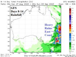
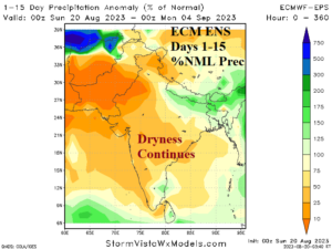
Fig. 3-4: The GFS 8-14-day heavy rain forecast for East Australia and the 15-day ECM ENS percent of normal rainfall forecast for India.
Shifting to the northern hemisphere, onset of a dry monsoon across India is about 3 weeks old. The 15-day outlook by ECM ENS is mostly drier than normal as the dry pattern is maintained (Fig. 4).
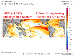
Fig. 5: Daily global SSTA analysis identifies strengthening Indian Ocean dipole and El Nino.
In the tropics, positive phase Indian Ocean dipole (+IOD) has developed and is increasing strength rapidly. El Nino is steadily strengthening and the daily Nino34 SSTA is now a buoyant +1.45C (Fig. 4). Waters off the West Coast of both North America and South America are increasing and supports dynamic model projection of a very intense El Nino later in 2023.
In Europe, another upper ridge pattern with connection to Northwest Africa heat is amplified across Spain to Central Europe in the 5-day forecast. The ridge has created ideal conditions for wildfire spread. The 5-day temperature extreme temperature outlook indicates risk of >100F across most of Southern Europe to the Black Sea region (Fig. 6). In the 6-10-day period, the Southwest U.S. upper ridge shifts east and is less amplified while a new cool upper trough moves into Western Europe. The 6-10-day forecast is vigorously cool in France/Germany to Scandinavia. Accompanying the cooler pattern change is a lot of rain (Fig. 7).
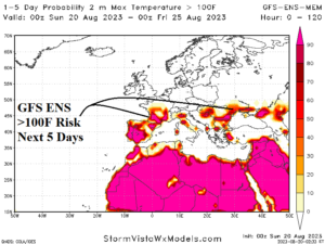
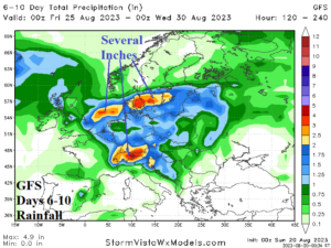
Fig. 6-7: The GFS ENS risk of >100F over the next 5 days and 6-10-day rainfall projection for Europe.