The Immense June 23-July 2 U.S. Severe Weather Pattern
07/03/2023, 5:18 am EDTUnexpectedly Wet During June Northwest to Southeast Australia
07/06/2023, 9:05 pm EDTHighlight: How effective is the recent wet weather pattern change in the Midwest States on drought? More rains on the way, shifting farther south.
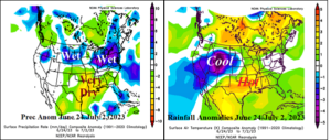
Fig. 1-2: June 24 to July 2, 2023, U.S. rainfall and precipitation anomalies.
Discussion: The recent wet weather pattern-change across the Midwest U.S. began on June 24 and has produced an unusually high amount of severe weather and heavy rains for the Dakotas and Ohio Valley (Fig. 1). However, just south of the wet weather belt, more dry weather accompanied by anomalous heat (Fig. 2) extending north from Texas was observed. Despite the recent rainfall, drought conditions persist across a large portion of the Midwest U.S. and Missouri Valley and Texas to Louisiana (Fig. 3). Soil moisture conditions have improved from Iowa to Kentucky (Fig. 4) but much more rainfall is needed to weaken the drought. The latest 15-day outlook trends much wetter for the central Great Plains, Missouri and Tennessee Valley(s) and vicinity (Fig. 5). NOAA recently issued a 30-day drought outlook revised to substantially weaken the Midwest U.S. drought (Fig. 6).
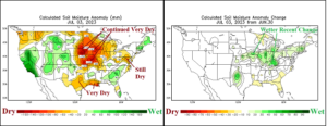
Fig. 3-4: Current soil U.S. moisture anomalies and the early July trend.
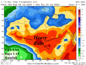
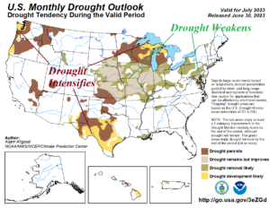
Fig. 5-6: The GFS ENS 15-day wet forecast for the Central/East-central U.S. and recent NOAA 30-day drought outlook.