North Atlantic Basin Week 2-5 Outlook: Screeching Halt to Larger Storms; Western Basin Development
09/28/2023, 12:24 pm EDTRainstorm Victoria/New South Wales; Heavy Rain for Southeast Brazil
10/02/2023, 7:55 am EDTHighlight: Low water supply for Midwest U.S. October harvest and Mississippi River transport stays critically low. Renegade rainstorm Southeast Australia. Heavy rains in Southeast Brazil mid-to-late next week.
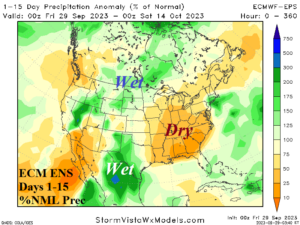
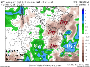
Fig. 1-2: ECM ENS 15-day percent of normal rainfall forecast across the U.S. and the CFS V2 rainfall anomaly outlook for October.
Discussion: 400 river level gauges are below “low water” on the Mississippi River due to the 2023 drought in parts of the Central U.S. The condition which is threatening the water supply for October harvest and barge travel along the Mississippi is worsening. The latest 15-day outlook by ECM ENS indicates mostly dry weather continuing in the Mississippi Valley (Fig. 1). The Climate Impact Company constructed analog (CIC-CA) precipitation outlook for October is developing wet weather across the Southeast to Mid-south U.S. However, CFS V2 indicates the wet weather risk may shift west to Texas (and vicinity) leaving the Southeast and East-central U.S. mostly dry (Fig. 2). Consequently, the difficult conditions on the Mississippi are likely to continue through mid-autumn. In November, the CFS V2 has wet risk for parts of the Mississippi River while CIC-CA is drier again therefore expectations of drought ending rainfall in November is below average. The winter outlook confidently forecasts above normal precipitation for the southern Mississippi River Valley, but the central basin may stay dry.
Meanwhile, a mostly dry climate attributed to El Nino and +IOD receives an interruption from a heavy rainstorm in southern New South Wales and eastern Victoria beginning later Monday, intensifying on Tuesday, peaking on Wednesday, and easing by next Thursday. A potent upper-level trough developing in Southeast Australia inspires heavy rainfall which based on ECM reaches up to 6-8 inches on the coastal Victoria/New South Wales border (Fig. 3).
Two sharp cold fronts bring heavy rainfall to Southeast Brazil at the beginning and ending of the 6-10-day period. The ECM ENS 15-day percent of normal rainfall forecast for Southeast/East Brazil now supports buoyant rains and an ending to the recent heatwave (Fig. 4).
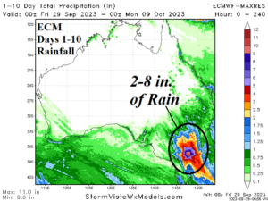
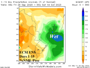
Fig. 3-4: ECM 10-day rainfall forecast for Australia and 15-day percent of normal rainfall forecast for ARG/BRZ.