Low Water on The Mississippi River Worsening
09/29/2023, 5:09 am EDTLooks Warmer Than Normal for the High Demand PJM Sector for Winter Ahead
10/05/2023, 8:02 am EDT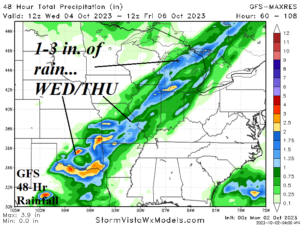

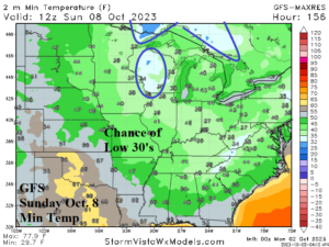
Fig. 1-3: The GFS 48-hour rainfall for WED/THU into the Midwest U.S. and steady low water at Tunica Mhoon Landing on the Mississippi River plus risk of low 30’s in the Upper Midwest next Sunday.
Discussion: On Wednesday and Thursday, a cold front will focus moderate rains across the Midwest States with heavy rain across the southern Great Plains (Fig. 1). This may be the only rain in the Midwest States through the next 2 weeks. Consequently, water levels on the Mississippi River maintain their 3-8 foot below “low water” regime and worsen to 4-10 feet by mid-October (Fig. 2). Although this week is very warm across the Great Plains, cooler weather is on the way for the weekend with risk of low 30’s in parts of the Upper Midwest next Sunday (Fig. 3).
In Australia, an unusually intense “renegade” low pressure area is forecast off the Southeast Australia Coast by early Thursday with central pressure 983 MB. Pressure that low will cause minimal hurricane wind gust potential across eastern Victoria and south coastal New South Wales. In this zone, 2-5 in. of rain is expected. Expect damage from high wind and flooding rains from this storm. Currently, a strong cold front extends from Southwest Australia to a low pressure south of Tasmania (Fig. 4). The upper trough supporting this cold front intensifies and causes an intense storm to form on the front as it passes through Southeast Australia midweek.
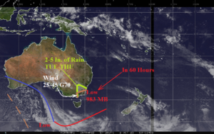
Fig. 4: Weather satellite view of Australia/New Zealand and an intensifying cold front/low pressure area heading for Southeast Australia.
In South America, wetter weather is returning to Brazil. Last week, above normal rainfall was observed in East-central and south coastal Brazil after a short dry period (Fig. 5). Elsewhere (especially Argentina) dryness prevailed. The 15-day outlook continues to project a confined area of very heavy rain across Southeast Brazil (Fig. 6).
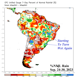
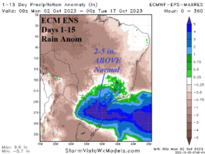
Fig. 5-6: The percent of normal rainfall across South America during the past week and the 15-day rainfall anomaly forecast for ARG/BRZ by ECM ENS.