Schedule of North Atlantic Seasonal Hurricane Forecasts for 2024
02/25/2024, 8:26 am EST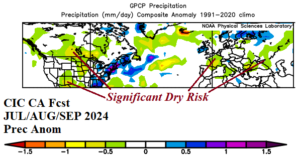
AG Market Weather/Climate Research: Mid-Latitude Ocean Forecast Contributes to a Dry Central U.S. Summertime Climate
03/04/2024, 11:54 am EST
Executive summary: In Part-1, a review of the influence of the 2014-23 Northeast Pacific marine heat wave (MHW) and North Atlantic warm hole (NAWH) on North America and Europe climate is presented. During this time, the MHW and NAWH patterns have profoundly affected North America and Europe climate. Interestingly, for the first time in 10+ years, the Northeast Pacific MHW is not present. The typical mild NAWH influence on Europe winter climate was pushed southward by presence of a Northwest Eurasia polar vortex during winter 2023-24 resulting in Northwest Africa drought and a record warm southeast North Atlantic basin. In part-2, the MAY-SEP 2024 forecast and influences on North America and Europe climate follow.
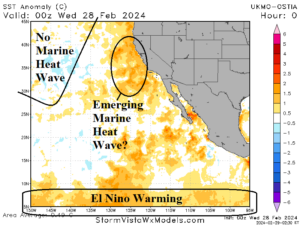
Fig. 1: The east and southeast North Pacific SSTA analysis reveal no marine heat wave near 145W and warming related to El Nino off the U.S. West Coast.
Discussion: For the first time in 10 years, a persistent marine heat wave (MHW) in the Northeast Pacific is not present (Fig. 1). There is some warming off the immediate West Coast most likely related to the 2023-24 El Nino episode. The influence of the cooler Northeast Pacific on winter 2023-24 climate patterns (vs. the previous 10 years) is profound! During the past 10 years, related to the Northeast Pacific warming, on average the winter pattern has featured a high-pressure area in the Northeast Pacific basin and a compensating polar vortex over Canada (Fig. 2). The consistency of the pattern created an optimum climate normal (OCN), a decadal pattern different from a standard 30-year climatology. During winter 2023-24 the opposite regime was present. Low pressure persisted off the California Coast and a compensating ridge formed over Eastern Canada centered on Ontario (Fig. 3). The pattern flip (along with El Nino) is causal for the (mostly) just-finished meteorological winter across North America (and Europe).
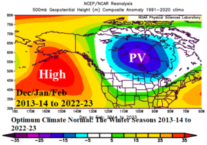
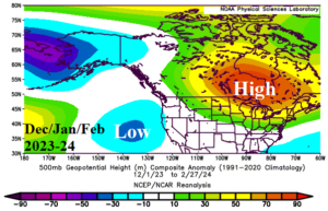
Fig. 2-3: The prevailing upper air pattern across North America during winter 2013-14 through 2022-23 (left) compared with winter 2023-24 (right).
The presence of the Northeast Pacific MHW has profoundly affected summertime climate across North America. The annual 2014-2023 upper air pattern (Fig. 4) identifies the Northeast Pacific ridge and while wintertime has a compensating downstream polar vortex over Canada, the summertime pattern usually features expansion of the Northeast Pacific ridge across the Northwest U.S. and Canada (Fig. 5). The summertime upper air pattern helps to explain the tendency for hotter than normal summer climate of the past 10 years and more recently the long-term drought in Canada causal to the horrific fire season last year.
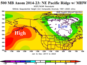
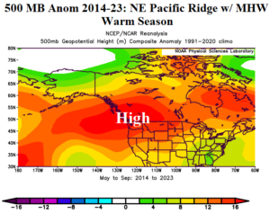
Fig. 4-5: The 2014-2023 annual upper air pattern across the Northeast Pacific and North America and the MAY-SEP pattern for the same 10-year period.
While the MHW regime was born in the Northeast Pacific during late 2013, an opposite sea surface temperature anomaly (SSTA) pattern formed in the North Atlantic basin. Since the mid-to-late 1990’s, a multi-decadal ocean climate pattern known as the Atlantic multi-decadal oscillation (AMO) changed to the (warm) positive phase. The warming North Atlantic caused an increased number of annual tropical cyclones and warming of the atmosphere biased toward the northern latitudes. The warmer northern latitudes began to accelerate ice and snow melt in Greenland and Northeast Canada during spring and early summer and the fresh-water runoff into the North Atlantic caused a stratified cool water layer usually south of Greenland surrounded by the warming related to the +AMO regime. Climate scientists coined this “cool pool” as the North Atlantic warm hole (NAWH).
Similar with the Northeast Pacific MHW climate pattern, the NAWH has generated an upper air regime most profoundly affecting Europe. During the 2014-2023 OCN, the prevailing upper pattern across the North Atlantic eastward to Western Russia has featured an upper trough near the NAWH and compensating ridge over Europe (Fig. 6) helping to explain the tendency for drought and warmer than normal winter and summer seasons.
The influence of MHW and NAWH on climate do not act alone. During the winter of 2023-24 an unusual amount of stratospheric warming caused a polar vortex to become semi-permanent over Northwest Eurasia (Fig. 7). Consequently, the high-pressure center over Europe was pushed slightly southward. The high-pressure area caused most Central and South Europe to observe another warm winter season. However, the southern displacement of the high-pressure area caused drought to develop in Northwest Africa (Fig. 8) and intensification of a MHW pattern off Northwest Africa. The MHW pattern has extended to the North Atlantic tropics leading to the warmest ocean temperature anomalies on record for the main development region (MDR) for North Atlantic hurricanes for this time of year (Fig. 9).
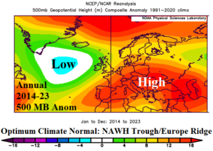
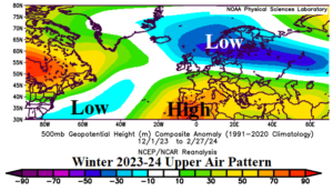
Fig. 6-7: The prevailing upper air pattern across the North Atlantic to Western Russia during the past 10 years (left) and just finished meteorological winter 2023-24 (right).
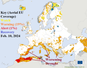
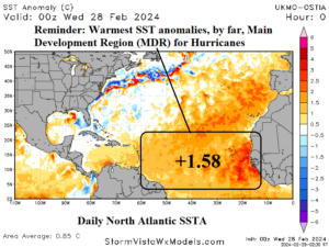
Fig. 8-9: Europe Drought Observatory soil moisture anomaly analysis reveals a Northwest Africa drought (left) while a vigorous marine heat wave off the Northwest Africa Coast extends to the tropical North Atlantic yielding a record warm tropical North Atlantic (TNA) index in the main development region (MDR) for North Atlantic hurricanes.
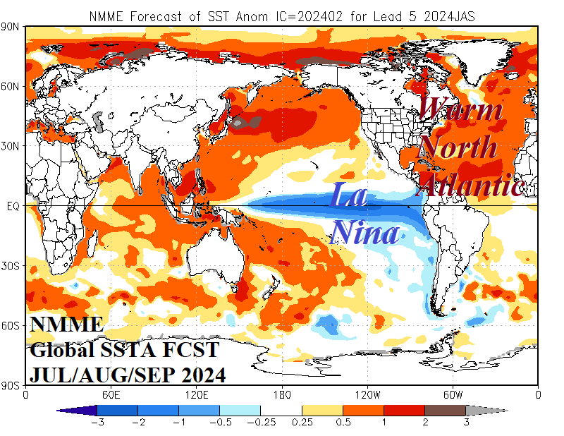
In Part-2, what is the Northeast Pacific and North Atlantic SSTA pattern forecast for the 2024 warm season (MAY-SEP)?