Does it Seem Like U.S. Summer is Lasting Longer?
08/25/2023, 9:47 am EDTExtraordinarily Warm (and Dry) U.S. Medium-range Forecasts
08/30/2023, 6:07 am EDT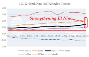
Fig. 1: The 12-week Nino SSTA region tracker indicates El Nino is slowly strengthening.
Discussion: El Nino is strengthening. Oceanic El Nino warmed to +1.5C in the Nino34 region last week (Fig. 1). Warming to >+1.0C finally reached the Dateline. The southern oscillation index (SOI) for August is projected near -1.00 which is the second monthly stronger El Nino-style -SOI of the past 4 months (Fig. 2). The atmosphere is slowly stepping into an El Nino climate. Interestingly, what drives a strong El Nino climate is large contrasts in the tropics between areas with convection and areas without. The SST pattern assists in driving that contrast. Thermal contrast is not very dramatic which may explain why the atmosphere is slower to react. Looking at the subsurface equatorial Pacific which has widespread moderate anomalous warmth (Fig. 3). By contrast, look at the 2015 El Nino which produced dramatic cooling in the subsurface west of the Dateline while all upper ocean heat consolidated east of the Dateline (Fig. 4). El Nino strengthening remains in the forecast, but dramatic intensification as observed with the 2015-16 El Nino is not likely.
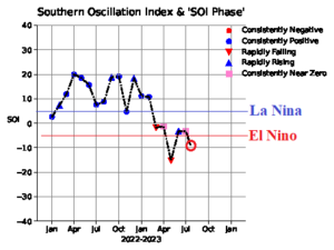
Fig. 2: The monthly southern oscillation index observations reveal an El Nino signature likely for August.
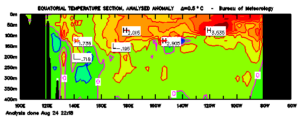
Fig. 3: Current equatorial Pacific upper ocean heat observations.
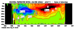
Fig. 4: By contrast to AUG-23, a look at AUG-15 when the last stronger El Nino formed. Note the sharp difference between thermal regimes either side of the Dateline.