Introducing Artificial Intelligence Forecast System (AIFS) from ECMWF…The First AI-Generated Precipitation Forecast
04/14/2024, 1:58 pm EDTEl Nino Fades; Speed of Development/Intensity of La Nina Ahead Uncertain
04/16/2024, 4:39 am EDTHighlight: Anomalous heat strongest California to Texas and Northeast, drought development Texas/New Mexico (Midwest drought eases), and considerable coastal tropical cyclone risk for AUG/SEP.
Executive Summary: The Climate Impact Company summer 2024 outlook valid for May through September is issued. The forecast is based on a transition from an El Nino to La Nina climate, warming of already very warm mid-latitude oceans, optimum climate normal, and anticipated drought zones. Forecast highlights for meteorological summer include a hot June for the Central U.S. continuing in Texas and the Southwest U.S. during July. Anomalous heat steadily intensifies on the West Coast peaking in August. The Northeast States are hot and humid for the entire summer season. Wet weather risk is centered on the Mid-south and Midwest with frequent severe thunderstorms while the northwest Gulf States are targeted for the stronger tropical cyclones later this summer season (and Florida/Southeast/Mid-Atlantic States could be added for September).
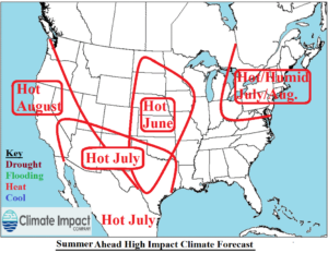
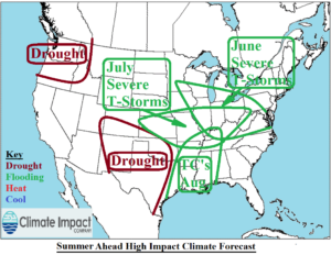
Fig. 1-2: The Climate Impact Company meteorological summer 2024 high impact climate zones.
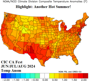
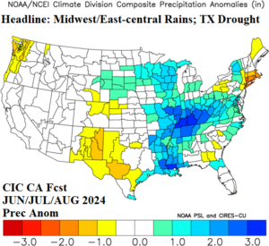
Fig. 3-4: The Climate Impact Company meteorological summer 2024 temperature and precipitation outlook.
Climate discussion: The U.S. warm season 2024 climate outlooks are based on the evolution of an El Nino climate shifting to a La Nina climate, anticipated for the mid-to-late tropical cyclone season, a moderating cool phase of the Pacific decadal oscillation (-PDO), and continued warm phase of the Atlantic multi-decadal oscillation (+AMO). There are several caveats to these predictions described below. Additionally, and a common practice with climate forecasts nowadays, is inclusion of optimum climate normal (OCN) which identifies recent climate trends vs. the long-term pattern. Additional factors such as soil moisture, especially just prior to the beginning of meteorological summer, are used to identify where summer extremes are most likely.
- ENSO: El Nino 2023-24 is collapsing. Subsurface waters in the equatorial eastern Pacific have cooled to well below normal. Up-welling trade winds will lead to rapid cooling of the sea surface temperature anomaly (SSTA) scheme near the Dateline eastward to the northwest coast of South America during Q2/2024 as ENSO becomes neutral followed by a shift into La Nina during July. The global climate will lag the oceanic ENSO phase change with a La Nina atmosphere likely by August.
- PDO: The PDO regime is a significant wildcard in the summer 2024 outlook, particularly through July. During 2013-14, a strong marine heatwave (MHW) formed in the Northeast Pacific and remained in-place with varying intensity for the remainder of the decade. Causal to the oceanic warming was emergence of a semi-permanent high-pressure ridge on the North America West Coast blamed for frequency of recent Western North America droughts. The MHW has shifted westward to the north of Hawaii in this decade. The warmer waters north of Hawaii vs. the relatively cooler water off the West Coast of North America has caused a long-term cool phase of the PDO which continues to persist. The -PDO pattern leaves the West U.S. susceptible too cool troughs into mid-summer which would create wet weather in the Central U.S. and persistent warmth east of the Divide. All forecast models indicate the cooling -PDO effect described to ease as summertime approaches.
- OCN: The emergence of MHW’s and persistence of the North Atlantic warm hole (NAWH) located south of Greenland during the past decade have profoundly affected North America (and Europe) climate. The expected weakening -PDO pattern increases the influence of OCN on the summer forecast which is important to the West Coast as anomalous heat is forecast which would not occur if the -PDO remains. The OCN signature on the entire U.S. is warmer than normal triggered by the warming of the mid-latitude oceans.
- AMO: The subtropical and tropical North Atlantic basin is the warmest (compared to normal) on record for this time of year. The anomalous warm waters are a leading catalyst to very active seasonal tropical cyclone activity forecasts for the 2024 season. Recently, the Gulf of Mexico and western North Atlantic basin cooled significantly. However, the cooling us ruled temporary and anomalous warmth is expected to regenerate during the summer season. Large areas of warm sea surface temperature anomalies (SSTA) are well-correlated to strong subtropical high pressure and warmer than normal temperatures across adjacent land masses which explains the persistence of hotter than normal summer seasons in the East U.S. The warm tropical/subtropical waters lead to above normal tropical cyclone risk which dampens hot risk for the Southern States later in the summer pushing the warmest SSTA to the Northeast U.S. and East Canada.
- Soil moisture: Currently, drought conditions are in-place over Western Texas to the 4-Corners Region and the South-central Great Plains to the Midwest States. Parts of the Northern U.S. from Washinton to Minnesota near the Canadian Border are also in drought. The mid-to-late spring pattern features beneficial rain for most drought regions. Once into summertime, the Midwest drought eases due to a thunderstorm pattern and the Texas/Southwest U.S. drought is likely to intensify. Once drought is well-organized, a feedback mechanism to the atmosphere can amplify high pressure ridging with a return signal to ground level accelerating heat and drying soils. This condition is most likely for Texas and the Southwest States during summertime.
May 2024 outlook: The May outlook is responsive to the -PDO regime previously discussed. The springtime -PDO climate bias is cool in the West. The upper trough causing the cool weather inspires a southerly flow out of the Gulf of Mexico to cause showers and thunderstorms that should help ease the drought conditions. East of the West U.S. trough, an upper ridge pattern is persistent and warms the eastern half of the U.S. The Mid-Atlantic States to Florida are also wetter than normal. A low confidence forecast, one much-needed, is dryness in New England where a wet winter and snow melt have elevated flood risk. Washington warmth and dryness accelerate drought.
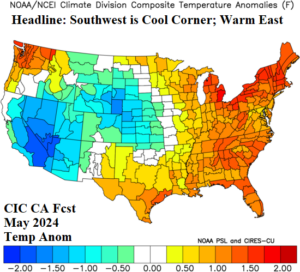
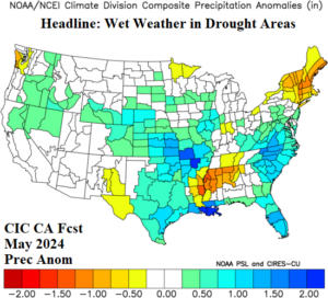
Fig. 5-6: The Climate Impact Company May 2024 temperature and precipitation anomaly outlook.
June 2024 outlook: High pressure crests over Texas causing anomalous heat and dryness. The Texas drought threat eased in May but roars back in June magnified by the anomalous heat. Occasionally, some of the hot weather associated with the Texas high pressure ridge extends to California. Ove the top of the Texas high-pressure ridge, severe thunderstorms are likely from the Midwest to the Mid-Atlantic States. The Southeast could be wetter than indicated. The Midwest drought continues to ease. Most of the U.S. is warmer than normal to start meteorological summer.
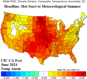
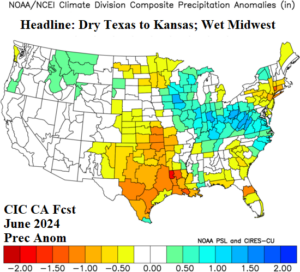
Fig. 7-8: The Climate Impact Company June 2024 temperature and precipitation anomaly outlook.
July 2024 outlook: The mid-summer forecast anticipates weakening of the -PDO climate. Therefore, the OCN climate will emerge, and anomalous heat risk is consistent on both coasts and across the developing drought region in Texas. Compensating for the mid-summer amplified high-pressure ridge areas is a weak trough in the Great plains responsible for keeping the strong to severe thunderstorm pattern going ending Great Plains drought risk. The Northeast Corridor is hot and humid and Texas heat could be excessive. Periods of extreme heat are also likely on the West Coast.
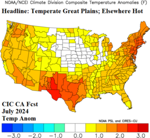
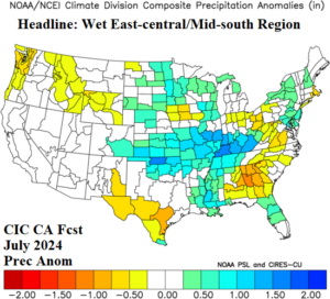
Fig. 9-10: The preliminary Climate Impact Company July 2024 temperature and precipitation anomaly outlook.
August 2024 outlook: An extremely active tropical cyclone year is anticipated. In August, the most likely risk area on the U.S. Coast for tropical cyclone impacts is the northwest Gulf region. Some of the attendant rainfall may bring benefit to the Texas drought. Wet weather also extends well inland due to tropical activity reaching the Tennessee Valley and parts of the Midwest States. Prior to any land-falling tropical systems, the Gulf region is hotter than normal. Warm mid-latitude SSTA guarantees anomalous warmth for late meteorological summer across the West Coast and Desert Southwest, the East Coast, and particularly the Northeast States.
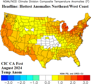
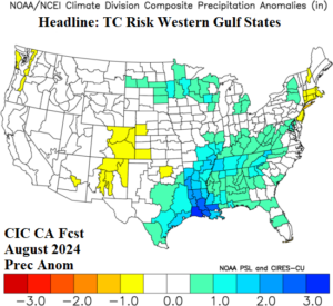
Fig. 11-12: The preliminary Climate Impact Company August 2024 temperature and precipitation anomaly outlook.
September 2024 outlook: Warm SSTA either side of the U.S. guarantees a warmer than normal September, likely for each of the 48 contiguous states. Hottest anomalies for late calendar summer are across the central Rockies, southern half of the Great Plains, and Northeast Corridor. The precipitation forecast is generated with below average confidence as a busy tropical cyclone season may yield a wetter than indicated forecast. For now, coastal strikes of tropical cyclones for September are highest in South Texas, the northern Gulf of Mexico, and the Southeast/Mid-Atlantic Coast.
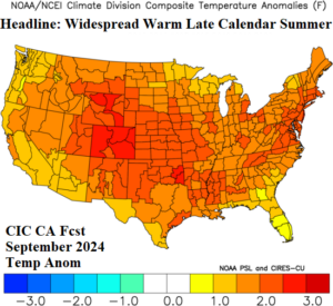
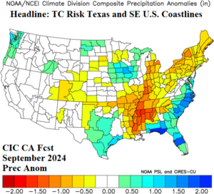
Fig. 13-14: The preliminary Climate Impact Company September 2024 temperature and precipitation anomaly outlook.
Special forecasts: Based on the constructed analog, the drought concern regions for JUL/AUG/SEP 2024 are Washington into Oregon, New Mexico and vicinity, and New England (Fig. 15). The Washington drought is underway, and expansion/intensification is projected with high confidence. The dryness across 4 Corners into Texas receives some beneficial late spring rain but reverses hot and dry once meteorological summer begins. The drought forecast in this region is above average. In New England, spring soil is soaking wet and getting wetter. However, the warm season forecast is warmer/drier than normal causing a low confidence drought projection for later this summer. Note that the Midwest shifts wetter.
The JUN/JUL/AUG 2024 CDD anomaly outlook indicates highest electricity demand due to anomalous heat is located across the Southwest U.S. including Texas, the Northeast Coast., and most of the Southwest States (Fig. 16).
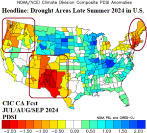
Fig. 15: The Climate Impact Company projected soil moisture anomalies valid for JUL/AUG/SEP 2024.
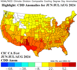
Fig. 16: The Climate Impact Company JUN/JUL/AUG 2024 CDD anomaly outlook.