ERCOT Heat to Become Less Intense: PJM-West Heat Spike Possible
08/11/2023, 11:59 am EDTNorthern Hemisphere Winter 2023-24: Increased Risk of SSW Events Triggering Arctic Air Generation
08/16/2023, 12:25 pm EDTHighlight: Plenty of high impact weather during the second half of August. Searing heat into the Midwest States, flooding rains Southwest U.S., and activating tropics.
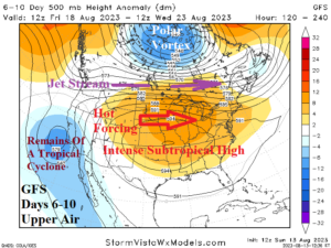
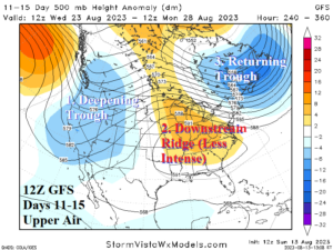
Fig. 1-2: The 12Z GFS upper air forecast for the medium range.
Discussion: A powerful tropical cyclone is forecast to move west and northwest in the East Pacific eventually joining forces with a West Coast trough amplifying the subtropical ridge over the Central U.S. in the 6-10-day period causing widespread excessive and possibly record heat (Fig. 1). In the 11-15-day period, the West trough elongates forcing the upper ridge farther east while the polar vortex in North-central Canada just-after mid-August rolls into Eastern Canada in the 11-15-day period (Fig. 2). A very dynamic/high impact weather pattern is produced!
Beginning with hot weather…Excessive heat is across the Northwest and South States now. The pattern change identified will push the Northwest heat into the Central U.S. joining forces with the well-established super heat in the Gulf States. South of the jet stream, the hot weather is made (more) severe, and extreme heat is likely to affect the Midwest States and certainly the Great Plains (and eastward) in the 6-10-day period (Fig. 3). Chicago has a chance at upper 90’s one week from today. In the 11-15-day period, the heat remains and expands into the Southeast forced by the jet stream which remains unseasonably strong between the Southeast heat and the East Canada chill (Fig. 4).
While extreme heat shifts northward, another major issue is potential for excessive flooding rainfall across the Interior West and Southwest U.S. including California (Fig. 5). This zone has observed a seasonably dry and hot climate during mid-summer. However, an upper trough entraining a tropical cyclone early in the 6-10-day period causes a long duration period of wet weather covering much of the West. Flash flood risk is highest in Southern California, the Southwest Desert, and the Great Basin!
Meanwhile, the tropics become busy with a large area of tropical rainfall suggesting presence of an emerging important tropical cyclone centered on the western Caribbean Sea in the 8-14-day period according to 12Z GFS (Fig. 6). At times, over the weekend, GFS has produced an intense tropical cyclone in the Gulf of Mexico indicating the potential for a significant storm.
Current U.S. weather watch, warning, and advisories indicate short-term interests to start this week are excessive heat related and focused on the Northwest States plus the Gulf States to the Mid-south U.S. (Fig. 7). The Northwest heat ends Friday while the Southern U.S. heat expands northward through the Great Plains.
The U.S. population weight CDD forecast indicates above normal national cooling demand this week and much above normal demand for next week (Fig. 8). The 12Z GFS indicates the much above normal demand could continue the last full week of August.
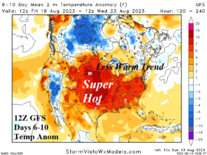
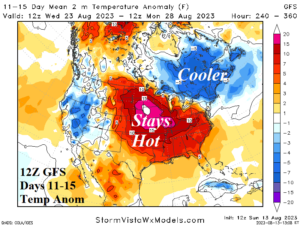
Fig. 3-4: The 12Z GFS medium-range temperature anomaly forecast for the U.S.
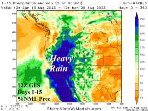
Fig. 5: The 12Z GFS 15-day percent of normal rainfall forecast for the West U.S.
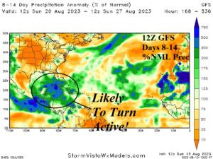
Fig. 6: The 12Z GFS 8-14-day percent of normal rainfall forecast for the tropics.
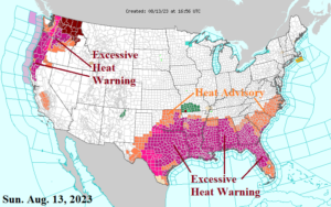
Fig. 7: Current NOAA/NWS weather watch, warning, and advisory areas.
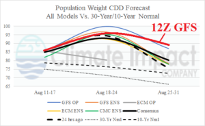
Fig. 8: U.S. population weight CDD forecast utilizing all models, their consensus, and comparing with 24 hours ago and the 30-year/10-year normal. The just-received 12Z GFS projection is added.