RAPID Cooling of Nino12 SSTA Region
04/03/2024, 8:49 am EDTEast Coast of Australia Excessive Rains
04/07/2024, 11:20 am EDT 
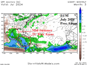
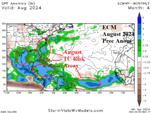
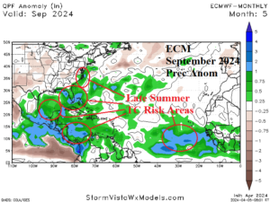
Fig. 1-4: The just-issued ECM percent of normal rainfall forecasts across the North Atlantic tropics for June through September.
Discussion: The European Center for Medium-range Weather Forecasts (ECMWF) has issued their once-per-month forecasts for the next 6 months. Glancing at the rainfall anomaly forecast in the North Atlantic tropics and subtropics for July through September helps to identify areas exposed to tropical cyclone risk. In June, early season tropical development is indicated across the western Caribbean with potential for a system to travel northward toward Florida (Fig. 1). In July, the southwest Gulf of Mexico and Caribbean Sea are wetter than normal due to tropical cyclone risk (Fig. 2). A July tropical cyclone could reach the Texas coast. By August, the tropics are busy with heavy rain areas identifying tropical cyclone risk in the Gulf of Mexico, Caribbean Sea, and U.S. Southeast Coast (Fig. 3). In September, anomalous wet climate indicates a robust tropical cyclone season continues from the Caribbean Sea to the eastern Gulf of Mexico and along the U.S. East Coast (Fig. 4).
The ECMWF temperature anomaly forecast for meteorological summer across the U.S. indicates “big heat” risk across the Interior West in June (Fig. 5), expanding from the Southwest U.S. across the Great Plains in July (Fig. 6), and remaining centered on the Great Plains in August (Fig. 7). Frequently, when the western North Atlantic basin is tropically active, a large area of hot (and dry) weather sets-up to the northwest placing that risk in the West-central and/or Central U.S.
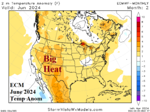
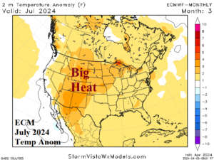
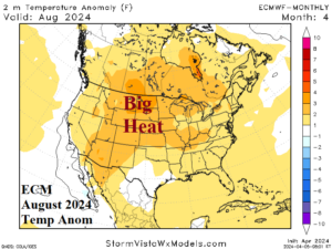
Fig. 5-7: The just-issued ECM temperature anomaly forecasts for the months of meteorological summer.