Just-issued ECMWF Outlooks North Atlantic Tropics and U.S. Summer 2024
04/05/2024, 9:00 am EDTClassic Modern-day Cold Season 2023-24 HDD Curve
04/08/2024, 5:04 am EDTHighlight: Changeable wet weather forecasts for the U.S. and South America. Extreme rain on Australia East Coast finally abates. More ahead!
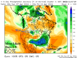
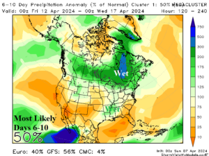
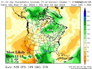
Fig. 1-3: Mega-cluster ensemble “most likely” percent of normal precipitation forecast across North America.
Discussion: The mega-cluster ensemble “most likely” precipitation scenario over the next 5 days features heavy rain across the Mid-south U.S. (Fig. 1). NOAA/WPC indicates a large area of >5 in. of rain possible from northeast Texas to northern Mississippi over the next 4 days. In the 6-10-day period, the “most likely” scenario utilizes the GFS forecast and indicates heaviest precipitation shifts to Ontario and vicinity although the Mid-south region remains wet (Fig. 2). There is potential for additional substantial rainfall in Texas in the 11-15-day period and some of that rain could reach the Missouri Valley and vicinity (Fig. 3). The Western Corn Belt misses most of the rainfall in the 15-day forecast.
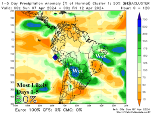
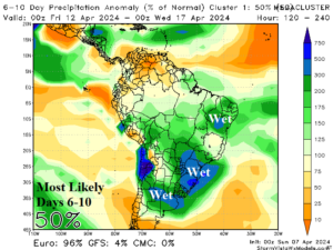

Fig. 4-6: Mega-cluster ensemble “most likely” percent of normal precipitation forecast across South America.
Heaviest rain in central portions of South America is due to thunderstorm activity mid-to-late week centered on Paraguay (Fig. 4). An upper trough draws tropical moisture southward to produce a large area of above normal rainfall in the 6-10-day period centered on Southeast Brazil extending to Argentina and Northeast Brazil (Fig. 5). In the 11-15-day period, the mega-cluster ensemble indicates Argentina is dry while wet weather continues across eastern Brazil (Fig. 6).
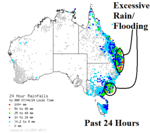
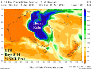
Fig. 7-8:The Australia 24-hour rainfall observations and GFS 8-14-day percent of normal rainfall forecast.
The East Coast of Australia continued to receive excessive rain causing flooding north and south of the New South Wales/Queensland state line and southeastern New South Wales (Fig. 7). The excessive rain abates early this week. However, GFS indicates another round of heavy rain in the 8-14-day period extending across northeastern to east-central continent and southeastward (Fig. 8).